
Finish roading jobs fast The Trimble® Access™ Roads software includes powerful tools to define, survey, and report your road. Supported formats: • - RXL • - LandXML • - GENIO • - 12d a Key in a road ...
Trimble

... added value at a glance: Appealing user experience and look & feel Easy usability, work-flow oriented user interface New 2D and 3D graphics engine Cleverly integrated cloud solutions Flexible ...
EPLAN Software & Service

... Professional, you can realise a wide variety of engineering tasks with just one piece of software solution: from creating schematics and planning mounting layouts in 3D to the virtual ...
EPLAN Software & Service

... corresponding 3D visualisation – all based on the digital twin from EPLAN Pro Panel. Smart Mounting leads assembly technicians step by step through the installation of DIN rails, cable ducts and electrotechnical ...
EPLAN Software & Service

SOLIDWORKS® 3D CAD solutions provide easy-to-learn, yet extremely powerful functionality that shortens product development time, reduces costs, and improves quality. Why Choose SOLIDWORKS 3D ...
SOLIDWORKS
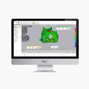
... form of measurement points, 2D images or volume data can also be conveniently evaluated with regard to geometrical characteristics or with nominal-actual comparison. In order to meet the most diverse requirements, the ...

... guides for training or day-to-day processes and quickly cascade information across your organization, with no programming or 3D skills necessary. Maximize operational efficiency using data Incorporate Guides into ...
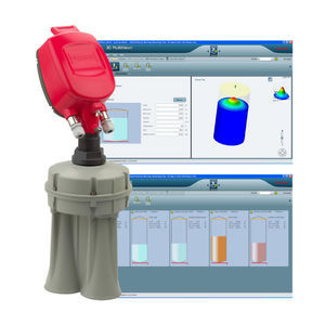
3D MultiVision is a Windows-based inventory management software for 3DLevelScanner or 3D Solids Scanner users who want easy and convenient access to ...

Nowadays, the SAPHIR 3D measurement and analysis software is one of the world’s best known and most successful developments in the optical and tactile measurement technology sector. SAPHIR impresses ...

... Simultaneous localization and mapping (SLAM) Other near-infrared 3D sensing applications A comprehensive NIR test solution from Radiant combines the TT-NIRI application-specific software ...
... Metrology software M3 is a High Performance Software for Capturing and Analyzing Point Clouds. M3 solves all the comprehensive process of scanning and point cloud management ...
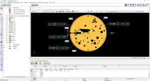
... three basic steps: •Measurement of 6 distances •Automatic calculation of errors •Report generation •Real time verification on 3D master •Historical error graph •Complete report •Monitor the long-term ...
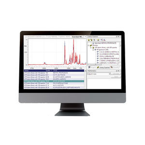
Panorama© software is a sophisticated modular spectroscopy software application for demanding end users that require special analytical functions. The software enables manipulation of ...
The PPL - PASCHAL - Plan light PASCHAL formwork planning for the next generation for the planning with BIM technology. PPL assists building contractor’s work preparation department so that the use of formwork can be planned in ...

Process optimization already starts with the corresponding software. Bihler Software bNX provides technically ground-breaking functions to support the complex tasks required for development, analysis, ...
... analysis of process data – trend and alarms Wizard controlled formula compilation Visual supported detail diagnosis (PDf-documents, 3D pictures, circuit diagrams) live cams for additional process monitoring Dual-screen ...
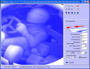
... 1,6 MHz for each axis! Maximum usable number of axes: 6 PC Connection via: Network Graphical 3D display with milling presentation and web preview 3D simulation ...
CNC-STEP GmbH & Co. KG
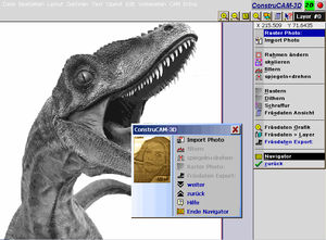
... latest CAD CAM software by CNC-STEP. On this page you will learn what this software is able to accomplish, no matter if you want to engrave or mill photos in 3D, manufacture ...
CNC-STEP GmbH & Co. KG
... topographic 3D maps This software is also suitable for topographic 3D map relief, and already, many schools and museums use it to create such 3D ...
CNC-STEP GmbH & Co. KG

... measure hundreds of thousands of positions simultaneously. The motion is amplified by software and animated in a 2D model. With the help of the WaveCam analysis software, changes in ...
... analysis software offering a comprehensive suite of tools for data acquisition and analysis. It provides a core package with the option to expand functionality through add-on modules, seamlessly integrated into one environment. ...
... Simulation Software WaveSim a digital twin Thanks to our optimal addition for our vibration measurement software WaveCam, products or services across diverse physical conditions can be predicted fast ...
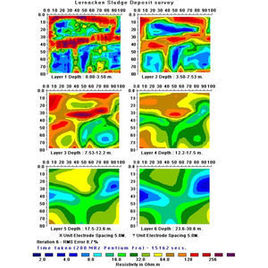
2D+3D PROCESSING SOFTWARE FOR ELECTRICAL TOMOGRAPHY, BASIC VERSION In areas where the geological structures are approximately two-dimensional (2D), ...
M.A.E. S.r.l.

... signal, performing a double Fourier transform in time and space domine. Transformed domine (f-k) is represented both in 2D and 3D and allows to underline signal coming from Rayleigh ...
M.A.E. S.r.l.
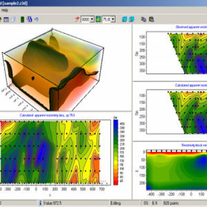
THREE-DIMENSIONAL INTERPRETATION OF ELECTRICAL TOMOGRAPHY DATA BY RESISTIVITY AND INDUCED POLARIZATION ZondRes3d program is designeed for three-dimensional interpretation of electrical tomography resistivity ...
M.A.E. S.r.l.

... AutomaticAtmospheric Correction techniques. The interpretationof radar data is made simple via visualization of fully geo-referenced 3D data. 1BIS Guardian employs Full Pit Monitoring (FPM)capabilities, stitching together ...
BOVIAR SRL
... tempering furnace (7 zones). Installation of the SCR supervision software (in client mode) on a touch pad to facilitate maintenance operations on the line. SCADA Supervision software in client mode ...
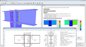
... extensive library of typical connection designs. Quick graphical editing of connection with a simple mouse click, directly on the 3D representation. Analysis Optimization of bolt positions according ...

... component Connection forces and resultants Overturning of walls Sliding of edge connections 3D Soil - Geotechnics Nonlinear 3D soil model: Mohr-Coulomb ...

... facilitate the design and feasibility study of PV projects. Thanks to the updated database, the software provides a geolocalized 3D mock-up that simulates the environment, and that provides ...

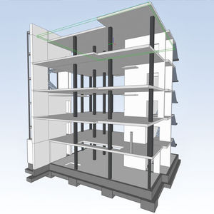
... model in IFC 4 format, generated by the various 3D architecture software (Revit, ArchiCAD, SketchUp …). For REVIT users, the elec calc™ BIM Plugin optimizes collaboration between the ...
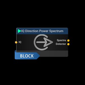
... 1µs) it is impossible to know which antenna is switched since the data link to and from the IsoLOG 3D DF antenna is within the ms range while the IsoLOG 3D DF antenna ...
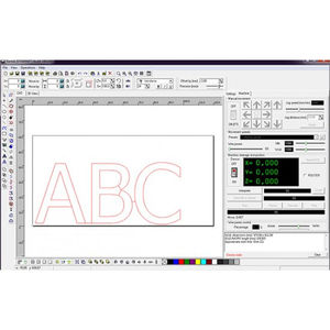
... Vector graphic design – CAD software • Conversion to G-CODE format – CAM software • Control – CNC software • Material layout planning – nesting All-in-one intuitive software ...
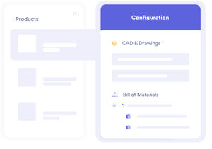
... multi-criteria search allows you to divide by 10 the time spent to find information (3D CAD, drawings, bills of material, specs...). Save time by viewing your files (Office, 3D, ...

... visualizing available satellites and their signals. Analyze GNSS activity with plots such as signal-to-noise, sky plot, position plot, 3D orientation visualization, time-plots and more. A GUI which ...
Please specify:
Help us improve:
remaining