
{{product.productLabel}} {{product.model}}
{{#if product.featureValues}}{{product.productPrice.formattedPrice}} {{#if product.productPrice.priceType === "PRICE_RANGE" }} - {{product.productPrice.formattedPriceMax}} {{/if}}
{{#each product.specData:i}}
{{name}}: {{value}}
{{#i!=(product.specData.length-1)}}
{{/end}}
{{/each}}
{{{product.idpText}}}

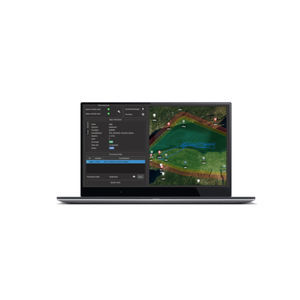
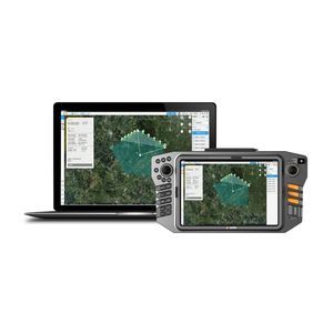
... meet specific user needs and make deployment to field crews easy and highly efficient. The advanced graphics rendering of mapping projects in LandStar 8 provides users with an unprecedented field experience. LandStar ...
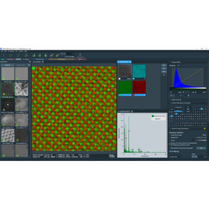
... microscopy software Thermo Scientific Velox Software combines comprehensive access to (scanning) transmission electron microscope (STEM and TEM) optics and detectors in order to provide you with superior ...
THERMO FISHER SCIENTIFIC - MATERIALS SCIENCE
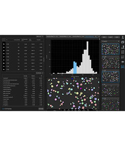
... default settings for non-expert user and advanced settings for experts. Automated image mapping Create image datasets with complimentary automated image mapping software.
THERMO FISHER SCIENTIFIC - MATERIALS SCIENCE
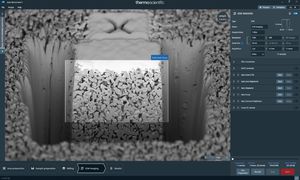
... provided by EBSD mapping. Spin Mill functionality Spin Mill Science is an add-on for Auto Slice & View 5 Software that enables site-specific large area polishing and 3D characterization. Available ...
THERMO FISHER SCIENTIFIC - MATERIALS SCIENCE

... image-to-scan alignment for iSTAR, Spheron, and Nodal Ninja external camera workflows Advanced image-to-scan texture mapping options with complete HDR Tone Map Editor Fly Mode for smooth, 3D fly-through navigation, ...
Leica Geosystems
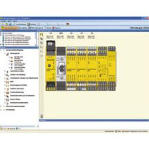
... complete the portfolio of high-performance engineering tools. Software tool SafeLogic Designer Intuitive engineering of individual or EFI-connected stations Detailed logic and hardware mapping ...

X-PAD Ultimate GO is the solution for those who need a simple and flexible field software to be used in all surveying and tracking applications with GNSS receiver and total station. Combined with our manual total station, ...
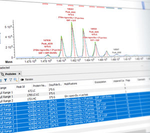
... biotherapeutic Leveraging the latest acquisition techniques and built on a heritage of proven performance, Biologics Explorer software delivers highly accurate and informative workflows for fully characterizing protein ...

... CORS (Continuously Operating Reference Station) product providing advanced support for Post Processed Geodetic Surveys and Mapping. RTK (single baseline vectors) service is possible via UHF radio(s) broadcasting from ...
TOPCON
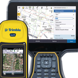
Effortless-to-use program Made to assistance your day-to-day study workflows Delivers genuine-time details syncrhonization Works with wide selection of Trimble GNSS and eye devices, in addition automatic radio station contacts Improved ...
Trimble
... A&E data collection for on-premise and cloud storage and analysis Proficy Historian is a best-in-class historian software solution that collects industrial time-series and A&E data at very high speed, stores it efficiently ...
General Electric

MWVirtualCom is a virtual serial port management software specially designed for serial port Ethernet servers. On the Windows system, the MwVirtualCom application program can virtual COM port, mapping ...

Secure & flexible inclusion of aggregated product & machine data in a wide variety of IT applications Secure Integration Server (SIS) provides a powerful OPC UA data integration layer. Based on the OPC UA aggregation server users implement ...
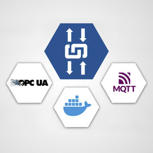
Container-based flexible IT/OT integration solution built on OPC UA with MQTT connectivity to IoT solutions edgeAggregator provides a powerful OPC UA data integration layer combined with a modern Docker based IoT edge solution. Users ...
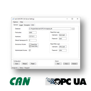
OPC UA Server for mapping CAN frames like objects • Scalable, powerful and resource-saving OPC UA server • Platform-independent and secure data exchange for CAN fieldbus devices • Executable without active ...
... tempering furnace (7 zones). Installation of the SCR supervision software (in client mode) on a touch pad to facilitate maintenance operations on the line. SCADA Supervision software in client mode ...
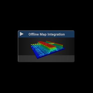
Offline Map Functionality for RTSA-Suite PRO Software for a dedicated continent of choice (e.g. Europe)
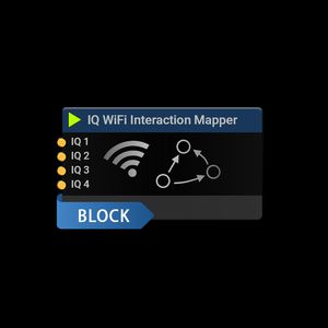
The IQ WiFi Interaction Mapper block shows the MAC, Vendor, SSID and Protocol used by all WiFi routers, nodes, phones etc. within detection range and the interaction between those as a MAC table and an interactive graph. Up to 4 IQ streams ...
... Kinematic) accuracy can also be achieved with post-processing, which is known as PPK (Post Processing Kinematic). Often used in mapping and photogrammetry, PPK can be used whenever real-time positioning is not necessary. ...
Septentrio

... technologies (i.e. cable locators) and highly enhances data visualisation to take utility detection and mapping to the next level. The uViewer software is designed to operate on site with any GNSS positioning ...
... management and 3D visualization have been introduced. In addition to underground assets detection and mapping, other functionalities are available for 3D mapping of sinkholes, inspection chambers and ...
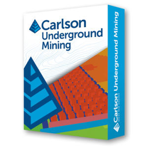
... produce accurate, customized reports with Carlson Software’s renowned ease of use. Mine plans can be quickly modified to compare alternatives, thereby ensuring the most efficient design. UNDERGROUND MINE MAPPING • ...
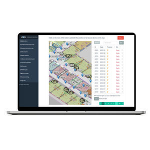
Manage your site's map, zones and beacon placement with Ubudu Map Manager. Manage your beacon infrastructure easily by placing beacons on the map using drag-and-drop Import beacons batch easily Export beacons batch from the Ubudu ...
Comprehensive cloud-based drone mapping software for flight planning, data collection, processing, and analysis Getting the right drone mapping software is essential. ...
... research and timely decision-making. Full Dynamic Video Integrated transmission solution with point, line and surface mapping and measurement in the dynamic video, synchronized with GIS map display, and share the ...

Post-processing software for Topcon's mass data solutions Processes the raw data for the following systems: IP-S3 Mobile Mapping System: Calculation of coordinates at measurement point of the ...
TOPCON EUROPE POSITIONING

... applications on a Windows PC. Multi-monitor support. Provides greater user control over Pixel Format to Visual Mapping. No additional 3D license is needed.
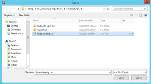
... PLC programming software. Handles multiple programs simultaneously Asset Mapping Provision for an asset naming map to translate names in the System Platform namespace to tag names in each PLC if the ...
AVEVA Group plc

Run your business in the cloud and on premises with visibility and security analytics built to rapidly investigate and prioritize critical threats The reality is that cybersecurity threats are becoming more advanced and more persistent. ...
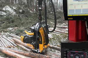
SYSTEMS FOR TRACK-BASED FOREST MACHINES N/A Address Ponssentie 22, Vieremä, 74200 View on map Phone 020 768 800 Services Sales, Factory, Training SYSTEMS FOR TRACK-BASED FOREST MACHINES OVERVIEW Making a track-based machine ...
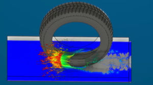
... these challenging applications, Abaqus offers a range of multiphysics simulation capabilities including sequential results mapping, fully-coupled solution procedures
Please specify:
Help us improve:
remaining