
{{product.productLabel}} {{product.model}}
{{#if product.featureValues}}{{product.productPrice.formattedPrice}} {{#if product.productPrice.priceType === "PRICE_RANGE" }} - {{product.productPrice.formattedPriceMax}} {{/if}}
{{#each product.specData:i}}
{{name}}: {{value}}
{{#i!=(product.specData.length-1)}}
{{/end}}
{{/each}}
{{{product.idpText}}}

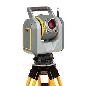
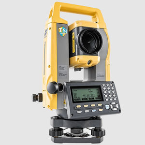
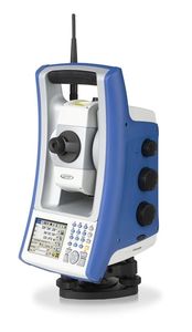
CTS-112R4 is one of the fastest total stations in his class, with a distance measurement speed of 0.3 seconds. This high-speed EDM allows you to perform routine operations much faster, saving time. The ...

HTS-720 adopts a 5.5-inch touch high-definition large screen with Android OS and new Android measurement software, more friendly for novice operation. The built-in camera can record the scene of the measurement points and provide live ...
Hi-Target Surveying Instrument Co.,Ltd

HTS-521L10 adopts a high-definition color screen to provide better human-computer interaction. The new optical design and absolute coding technology improve the measurement performance. High-precision compact bead shafting and sealed ...
Hi-Target Surveying Instrument Co.,Ltd

HTS-420R Total Station Dual-axis reflectorless total station, provides an efficient measurement experience. Dual-axis compensation Configuring ...
Hi-Target Surveying Instrument Co.,Ltd

Made to face any challenge, task or project, the Leica TS16 automated total station will reliably support you and deliver accurate data when and where you need it. With the engaging Leica Captivate field ...
Leica Geosystems

Trimble SPS Series Universal Total Stations can be used for even greater accuracy when performing fine or finished grading, with blade guidance to 2-5 millimeters (0.007 to 0.016 feet).
Trimble Navigation - Construction Division

With prism-free measurement technology, the TS-C100 total station can tackle with all kinds tasks even in harsh environment with high speed and high efficiency. Featured programs such as coordinate measurement, ...

The TS-C200 is a high-end manual total station, enabling you to carry out high-demand survey tasks even in harsh environment. With its higher accuracy, longer range and greater versatility, you can solve ...

The Zoom95 is the true flagship of the GeoMax TPS portfolio. Featuring advanced STReAM360 technology, this one-person total station substantially minimises the time of any survey task and maximises your ...
GeoMax

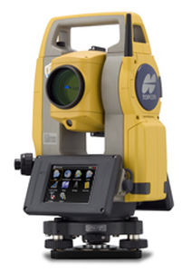
... New Ultrasonic motor direct drive World's smallest!* Highly mobile super compact body World's lightest!* 5.7kg robotic total station Best in class with Topcon manufacturing quality Compatible with ...
TOPCON
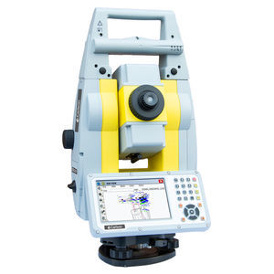
Trimble SX12 Scanning Total Station Built for seamless workflow integration and better, faster results in every field. With the NEW Trimble SX12 Scanning Total Station ...
Trimble

Built for job site mobility, the flagship iX Series ultrasonic robotic total station enables accurate and productive workflows for highly demanding survey and construction applications. Precisely lay ...
SOKKIA

Advanced features for maximum measurement versatility and unmatched product and data security. The FX total station provides the advantage of on-board Windows® CE operating system and comes standard ...
SOKKIA

The iM-100 (Intelligent Measurement Total Station) incorporates all the features you need at a cost-efficient price. It will handle your most demanding survey layout or as-built project needs. You ...
SOKKIA

Boasting an integrated Android operating system and specialized Android software, SLT12 seamlessly integrates cutting-edge technology into every measurement task. The two high-definition touch displays elevate operational fluidity, while ...
SatLab Geosolutions AB

SLT10 adopts a high-definition color screen to provide better human-computer interaction. The new optical design and absolute coding technology contribute to better measurement performance. High-precision compact bead shafting and sealed ...
SatLab Geosolutions AB

... the SLT Series is built to last. Delivering Quality Equipment Manufactured in an ISO, and CE certified factory, each total station is made with proper protocol and procedure that adheres to every ...
SatLab Geosolutions AB
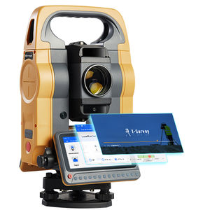
HTS-720 features a 5.5-inch touch high-definition large screen, powered by the Android operating system and our brand-new Android measurement software. With the addition of a built-in camera, measuring and stakeout tasks have never been ...
HTS-521L10 adopts a high-definition color screen to provide better human-computer interaction. The new optical design and absolute coding technology improve the measurement performance. High-precision compact bead shafting and sealed ...

HTS-420R Total Station is a reflectorless total station and offers an efficient measurement experience. Automatic error elimination and accuracy compensation thanks to ...


... new solution for staking out measuring points quickly and accurately on horizontal or vertical surfaces using robotic total stations. After reaching the point to be measured, the particular measuring ...
... If required, a coordinate system can be defined by applying the stationing function. This e.g. allows to alter the base station's location resulting in an almost unlimited area of operation. The receiver has a vertical ...

The GTL series of scanning robotic total stations combines a fast laser scanner and total robotic station all in one efficient system. You get the efficiency of a ...
TOPCON EUROPE POSITIONING
Advanced accuracy, faster workflows We designed this powerful, cost-effective manual total station to deliver the latest technological capabilities in a small, sleek design. It features an ultra-powerful ...
TOPCON Positioning Systems
Enhanced Reflectorless Total Station Long EDM range measuring distance: reflectorless up to 600m and up to 7,000m in prism mode Dual display as standard equipment Easy transfer to a PC ...
PENTAX Precision
E3 / E3L is a high precision manual total station, with accurate angle and distance measurement. It can work reliably and deliver accurate results even in harsh environments. And its simple operations ...
Windows® CE is ready in a lightweight, compact body MAGNETTM Field On-Board Application Software Fast and Powerful Reflectorless EDM LongLink Data Communication* Advanced Angle Measurement System Long-lasting ...
TOPCON

STONEX R1Plus Total Station, precise distance and angles measurements, concentrated in 5 Kg of pure technology. The perfect tool whenever the topographic works requires a light and fast machine, all day ...
Stonex

MODEL:NTS-342R6A ●600m reflectorless measurement ●Laser pointer, easy to find target ●T-P sensor, automatic correction ●EDM Trigger Key ●Data transfer and storage ●Concentrated ball bearing ●Totally new design for battery ●Bluetooth transportation
South Surveying & Mapping Instrument Co., Ltd
Introducing the powerful Spectra Precision® FOCUS® 30 Total Station. This fully robotic motorized solution provides improved speed, accuracy and precision in measurement. A robotic instrument moves the ...
Spectra Precision
• Infrared Ranging Technology • Absolute Coding Angle Measurement • Simple to Operate • Large LCD Display • Various Measurement Procedure • Road Design and Layout Procedure
• Non-Prism Laser Ranging • Absolute Coding Angle Measurement • Double Axis Photoelectric Tilt Sensor • Simple to Operate • Large LCD Display • Various Measurement Procedure • Massive Data Store

·Large data memory with 16,OOO points. ·Easy to operate with soft keys. ·Alpha key input. ·Recession,Lay—off,Remote elevation,Offset,MLM,Area measurement.
... instrument only. Customers benefit from technical guidance and support for both the robotic total station and SurvCE or SurvPC from one company. CRx Robotic Total Stations ...
Please specify:
Help us improve:
remaining