
{{product.productLabel}} {{product.model}}
{{#if product.featureValues}}{{product.productPrice.formattedPrice}} {{#if product.productPrice.priceType === "PRICE_RANGE" }} - {{product.productPrice.formattedPriceMax}} {{/if}}
{{#each product.specData:i}}
{{name}}: {{value}}
{{#i!=(product.specData.length-1)}}
{{/end}}
{{/each}}
{{{product.idpText}}}

Length: 262 mm
Width: 142 mm
The AlphaUni 20 (or AU20) is a cost-effective, multi-platform mobile mapping system of premium class. As a result of six years of innovation and product development, it harnesses the power of CHCNAV's state-of-the-art LiDAR technology. ...

... as agricultural and forestry surveying, power line inspection, material pile volume calculation, and data collection in underground spaces. With the RS10, surveyors are able to overcome the challenges of surveying ...

Length: 32 cm
Width: 21 cm
... years of research and data capture experience. AlphaUni 900/1300 are fully integrated systems with a high-precision laser scanner featuring Riegl's unique Waveform-LiDAR technology and high-accuracy inertial navigation ...

Measuring distance: 0 m - 120 m
Lixel X1 real scene 3D reconstruction scanner – a compact, powerful, and precise LiDAR scanner for capturing real-world scenes and generating detailed 3D models instantly without post-processing. Powered ...

Length: 227 mm
Width: 98 mm
Measuring distance: 105 m
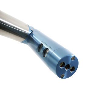
... the Cygnus Handheld LiDAR Scanner supports and assists you in 3D point cloud data acquisition efficiency to the fullest. No need to rely on GNSS satellites, Cygnus can help to obtain data in any outdoor, indoor, underground ...

Measuring distance: 200, 500 mm
... easily with a single operator Measures non-cooperative targets to deliver usable data even in harsh, wet, and dusty underground conditions Fast data acquisition time lets you get in, survey, and then get out ...
... Map inaccessible underground areas to ensure operations keep employees safe. C-ALS SUPPORTS SUCCESSFUL PROJECTS C-ALS gives you new underground mapping capabilities. You can safely, quickly and reliably ...
Carlson Software

... ensuring that nothing is being missed during the mapping process. The ZEB Revo RT is an ideal solution for indoor or underground data capture, of small to medium size spaces. Hard-to-reach areas like vents, manholes, ...
Measuring distance: 40 cm - 7,900 cm
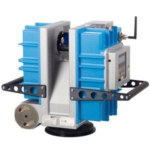
Based on the high quality laser scanner Z+F IMAGER®, Zoller + Fröhlich GmbH and DMT GmbH & Co. KG have developed an explosion proof 3D laser scanner. The Z+F IMAGER® 5006EX pioneers surveying in underground ...

... hands-free operation under unpredictable environments in underground mines. This specially engineered system is a perfect multi-use tool for your advanced 3D laser data capture and mobility needs in underground ...
Please specify:
Help us improve:
remaining