
Quadrotor drone MineFlycivilianfor underground mininginspection


Add to favorites
Compare this product
Characteristics
- Type
- quadrotor
- Applications
- civilian, for underground mining, inspection, instrument, mapping, observation
- Other characteristics
- autonomous, lightweight, with thermal camera
- Endurance
30 min
Description
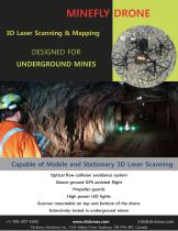
MineFly is a complete drone-based 3D laser scanning and mapping system that has been specially designed for GPS-deprived areas, such as underground mines and building interiors. This aerial drone is compact and lightweight, equipped with a 3D laser scanner, ample LED lighting, sonar sensors, an HD camera and several low resolution cameras. These features allow the MineFly Drone to meet the challenging requirements of underground mine mapping and surveying.
The system employs Simultaneous Localization And Mapping (SLAM) algorithm to combine the 2D laser scan data with the laser sensor position to generate accurate 3D point clouds. The MineFly drone enables rapid data capture of 3D point cloud with real time or off-line map generation. An on-board collision avoidance system helps the operator navigate through hard-to-access and narrow openings.
The 3D mapping is based on Clickmox Solution’s proprietary software that allows generation of accurate point cloud without any external positioning system. From the point cloud, the system generates the map in three dimensions. The process of map generation can be accomplished in real time or offline as per user’s preference. During real time processing, the position of the drone is also calculated, which can be used for autonomous operation.
VIDEO
Catalogs
MineFly Drone
1 Pages


*Prices are pre-tax. They exclude delivery charges and customs duties and do not include additional charges for installation or activation options. Prices are indicative only and may vary by country, with changes to the cost of raw materials and exchange rates.