
{{product.productLabel}} {{product.model}}
{{#if product.featureValues}}{{product.productPrice.formattedPrice}} {{#if product.productPrice.priceType === "PRICE_RANGE" }} - {{product.productPrice.formattedPriceMax}} {{/if}}
{{#each product.specData:i}}
{{name}}: {{value}}
{{#i!=(product.specData.length-1)}}
{{/end}}
{{/each}}
{{{product.idpText}}}
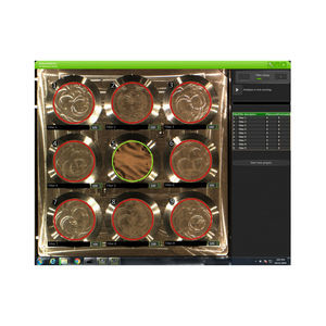
Since the introduction of electron microscopes in the 1930s, scanning electron microscopy (SEM) has developed into a critical tool within numerous different research fields, spanning everything from materials science, to forensics, to industrial manufacturing, ...
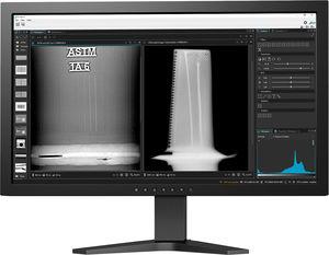
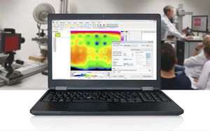
... Enhancement and Archiving Software With its state-of-the-art digital image enhancement and analysis functions, VISTAPLUS V is the perfect software for rapid and precise evaluation of x-ray radioscopic ...
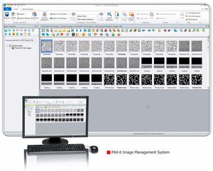
... difficulty of capturing, organizing and analyzing high-resolution images without the aid of the PAX-it Image Management System. Through the help of the high quality system, numerous images can efficiently ...
... compliant system. All-in-one All functions from image acquisition, analysis and related report generation, to export, archiving and database management are included. Well-tried For 10 years the software ...

... light for object detection. Part of the Radiant Vision Systems TrueTest™ Software family, the TT-NIRI module provides the benefits of TrueTest Software to efficiently perform image-based measurements, ...
... Fast and intuitive image acquisition software for the M-series (M-pad, M-link, M-ray, M-focus and M-touch) of portable RX products. It allows asynchronous and synchronous control of both X-ray emission ...
... Software for the control of the WideXcan X-ray system. It allows the positioning of each structure in a simple way, as well as an automatic communication with Det-X for image acquisition. Main features ...

... monitoring of production data VISION SYSTEMS: Image acquisition aimed at parts control, measurements, pick & place… SYSTEM INTEGRATOR 4.0: Integration in the 4.0 domain of hardware and software ...
... production systems.
Description details
- Universal software platform for IMAGO products (from smart cameras to vision sensors) covering image acquisition, I/O, parameterization,
... toolbars, zoom in or out, mirror or rotate image. • Acquisition Menu - Set exposure time, acquire single, multiple (averaged) or continuous images, live video preview, toggle image corrections, ...
... Active Thermography Software The active thermography software IRBIS® 3 by InfraTec is a modern and universally usable tool for thermographic material testing. Active thermography allows for a non-destructive detection ...
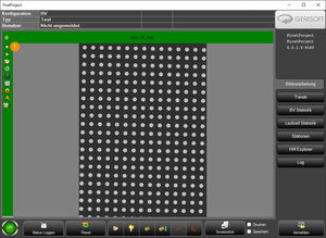
... Viper.NET® software, developed and maintained by GEFASOFT over many years, is a modular framework that simplifies and accelerates the development and use of industrial image processing applications. In addition to ...
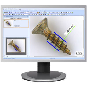
... QuickPHOTO microscope software is being developed by PROMICRA since 2004. It includes programs and modules for image acquisition, processing, and measurement. Straightforward user interface available ...
PROMICRA
... High-performance software for digitizing and printing Microfilm. • Scan to file PDF,TIFF,JPEG,BMP etc • Scan to Print • Image Correction • SCANNER Control • MARS Control Application software Major ...
... call away. Dive into scientific image processing with ease, using our core features designed for both efficiency and simplicity. Our software provides essential functions such as constructing and implementing image ...
MIPAR
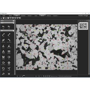
... Perfect Image is the market leader in metallography image analysis, enabling our laboratory clients to perform accurate quality control. The software’s different features are ideally suited to all applications. ...
... most user-friendly and robust NDT image analysis software in the industry for image acquisition and inspection. The accuracy of DynamIx VU software is a result of ...
... / Rotation Side by side comparison Multiple images stitching Easy export /save images Superpower Zoom (up to 500%) Detailed Image information tag Software Features All-in-one ...
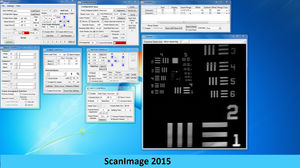
... ScanImage is imaging software for scanning microscopes developed by Karel Svoboda and coworkers (Pologruto et al, 2003) and judiciously maintained by members of the Svoboda lab, first at CSHL and then at Janelia Farms, HHMI. It is hard ...
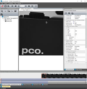
... Excelitas offers a comprehensive selection of software products for use with PCO cameras to help optimize your application. In addition to our camera control software applications, software development ...
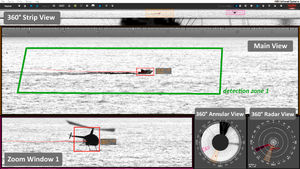
... Unlimited number of intrusions detected over 360° CYCLOPE is an advanced image processing software analysing panoramic images captured by the SPYNEL Wide Area Surveillance sensors in real-time. CYCLOPE ...
... patterns. The integrated image analysis in the software allows an easy and reliable interpretation. Designed to facilitate manual patterns and guarantee a perfect repeatability of the results, the PRESI Touch Manual ...
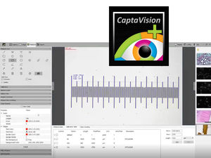
... powerful software package, exclusively developed to seemlessly integrate with our Excelis™ line of microscope cameras. Featuring a logical workflow, CaptaVision+ provides for precise camera control, image acquisition, ...
... nearly a thousand completely self-developed image processing operators and a variety of interactive development tools, including 140+ module tools. supporting a variety of operating systems and image acquisition ...
the best suppliers