... produce accurate, customized reports with Carlson Software’s renowned ease of use. Mine plans can be quickly modified to compare alternatives, thereby ensuring the most efficient design. UNDERGROUND MINE MAPPING • ...
... GNSS module to add precise coordinates to images. This workflow is for drone pilots who have Reach M2/M+ on a drone for PPK mapping. Kinematic processing Get precise track of measurements using raw data from the base and rover. This ...
... configuration using ConfigStage is child's play. This free Windows software for parameterizing the CPU and communication interfaces is intuitive to learn. The graphical assignment ( mapping) of external Modbus and CAN ...
... KC Implementation software is the robot application deployment software. Software features include robot model management, map management, fleet management, and configuration management. It is a powerful ...
... Make informed strategic decisions about your supply chain based on detailed analyses using large amounts of data with W2MO Supply Chain Engineering. Gain agility, speed and efficiency through strategic planning Easy to use and powerful Freely ...
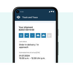
... Shipment tracking software makes sure that you always know where your shipments are. In real time. Order tracking across all forms of transport Users can save their own settings Traffic light status indicator for easy ...
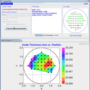
... The next generation of ellipsometry software has arrived with CompleteEASE®, our revolutionary new software for Woollam ellipsometers. It’s easier than ever to use, and with the world-class quality you’ve come to expect ...
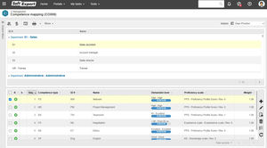
... Effectively manage all of your company's competencies through mapping, development, monitoring, and evaluation of each team member. Track progress on established actions and performance evolution, gaining a holistic and comprehensive ...
SoftExpert
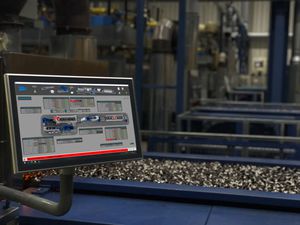
... tempering furnace (7 zones). Installation of the SCR supervision software (in client mode) on a touch pad to facilitate maintenance operations on the line. SCADA Supervision software in client mode on a touch pad Supervision ...

... MWVirtualCom is a virtual serial port management software specially designed for serial port Ethernet servers. On the Windows system, the MwVirtualCom application program can virtual COM port, mapping the TCP Socket connection ...
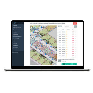
... Manage your site's map, zones and beacon placement with Ubudu Map Manager. Manage your beacon infrastructure easily by placing beacons on the map using drag-and-drop Import beacons batch easily Export beacons batch from the Ubudu MapTool application ...

... urban environments alike. MIPAR software can accelerate the critical analysis of complex visual imagery and provide fully automated characterizations of specific regions of interest. For example: Our drone imaging software ...
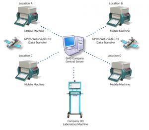
... Xenemetrix Geological Mapping Solution (GMS) include compact size 50W tube power mobile analyzers that can easily be transported between sites, or robust bench-top systems stabile for installation in mobile laboratory. The advanced software ...
... Condor – 3D GPR Processing & Interpretation Software Condor is modern processing, visualisation and interpretation software for the efficient management of Raptor 3D GPR array data. Boost performance and improve workflows Our ...
ImpulseRadar
... and Microstation® or synchronizes ETAP with other applications such as Intergraph SmartPlant® Electrical. Customizable data mapping, intelligent error checking, and automated one-line diagram generator are amongst the many utilities provided ...
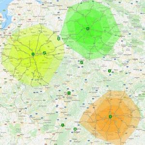
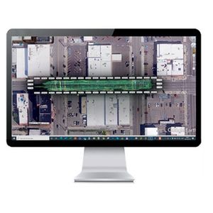
... different technologies and operations also called services such as: Cartography: the design and production of maps Mapping: the process of using maps delivered by geographical information systems (GIS) to display map and overlay ...
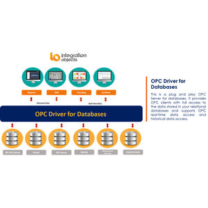
... benefit from an intuitive and graphical configuration environment to easily set up their databases connections and tables mapping. This OPC driver for databases is the bridge that you have been looking for to establish an OPC link between ...

... Experience significant benefits from incorporating hundreds of fire and intrusion alarms into Arteco’s video event management software functionalities, including: Quick Configuration: Arteco’s EAD4 Card converts the analog PSTN signals ...
... Standalone application that allows to display, edit and analyze clouds of millions of points captured by fixed or mobile scanners, LiDAR technology or generated by photogrammetry applications. Point clouds can be imported in the most common formats on ...

... meet specific user needs and make deployment to field crews easy and highly efficient. The advanced graphics rendering of mapping projects in LandStar 8 provides users with an unprecedented field experience. LandStar 8 is built around ...
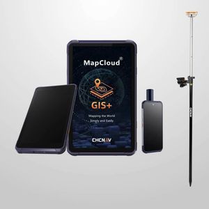
... by CHCNAV is a field data collection software with a powerful mapping engine. It offers seamless integration with popular GIS file formats for both import and export, maintaining compatibility with existing software ...
... The Megger GOOSE Configurator (MGC) provides mapping of the binary inputs and outputs of the SMRT/FREJA test set to the desired GOOSE messages. The GOOSE messages are read from available SCL (Substation Configuration Language) files ...
... output text file with position information or geotagged images can then be used directly in major photogrammetric mapping or 3D Survey software. Ultimate Efficiency Reduced Workload The PPK method makes it possible ...

... predefined maintenance plans, clear maintenance tasks and availability on the go Full transparency and quick access to data Mapping and archiving all maintenance actions and error messages in the digital maintenance logbook Valuable ...
... StuderWINprogramming is the perfect software package for the offline programming of grinding machines. Workpiece-oriented data management prevents data chaos and enables rapid retrieval of the required data. This software ...
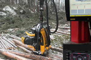
... Product overview
- Product name: Systems for track-based
- Brand: Ponsse
- Category: Information systems
- Intended use: data management for track-based platforms
Key features
- Data collection
the best suppliers