
{{product.productLabel}} {{product.model}}
{{#if product.featureValues}}{{product.productPrice.formattedPrice}} {{#if product.productPrice.priceType === "PRICE_RANGE" }} - {{product.productPrice.formattedPriceMax}} {{/if}}
{{#each product.specData:i}}
{{name}}: {{value}}
{{#i!=(product.specData.length-1)}}
{{/end}}
{{/each}}
{{{product.idpText}}}
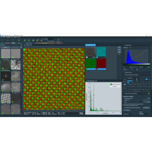
... All-in-one Thermo Scientific Velox Software was meticulously designed to offer comprehensive and advanced capabilities for both (scanning) transmission electron microscopy and transmission electron microscopy. It provides a fast and efficient ...
THERMO FISHER SCIENTIFIC - MATERIALS SCIENCE

... electron microscopy and cross-platform imaging automation software. Correlative Electron Microscopy Software Thermo Scientific Maps Software is an imaging and correlative workflow software ...
THERMO FISHER SCIENTIFIC - MATERIALS SCIENCE
... default settings for non-expert user and advanced settings for experts. Automated image mapping Create image datasets with complimentary automated image mapping software. Specifications Measured ...
THERMO FISHER SCIENTIFIC - MATERIALS SCIENCE
... control of your safety management program with real-time, on-demand data. iNet Control+ is a new comprehensive management software designed to increase safety productivity. This centralized one-stop data shop helps you do more with ...
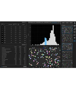
... from mass spec characterization. With the use of intuitive visualizations, Biologics Explorer software gets you from sample to insight - fast! The software provides the ability to immediately see patterns and features ...
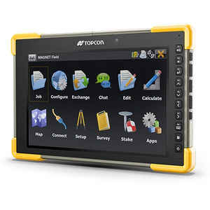
... and digital levels. Use cases Land surveying, stakeout, and cadastral projects Construction layout Roadwork Utility mapping Share data between equipment and users in the field or office MAGNET Enterprise allows secure project ...
TOPCON
... Biological, Radiological, and Nuclear) simulation and modelling software solution Urban Aware is an advanced CBRN (Chemical, Biological, Radiological, and Nuclear) simulation and modelling software solution developed ...
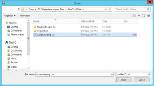
... programming software. Handles multiple programs simultaneously Asset Mapping Provision for an asset naming map to translate names in the System Platform namespace to tag names in each PLC if the names are ...
AVEVA Group plc

... applications on a Windows PC. Multi-monitor support. Provides greater user control over Pixel Format to Visual Mapping. No additional 3D license is needed. ...

... Redefine SIEM to unleash analyst potential and outpace adversaries with speed, scale and accuracy Empowering today’s modern SOC with enterprise-grade AI As the cost of a data breach rises and cyberattacks become increasingly sophisticated, the ...

... Rely on this advanced P4 software debug tool to more easily optimize software written in the P4 programming language. Speed Up Software Development for the Data Plane Reduce your time to market ...
... Overview
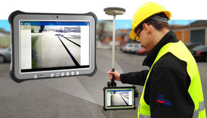
Getac Virtual-GPS (VGPS) is a
software utility that replicates physical GPS output to multiple virtual COM ports, enabling several COM‑based and modern applications to share a single GPS source on Windows-based Getac ...

... surfaces, planes, cylinder, and cylinder center lines. Descartes lets you create high-fidelity images to support precision mapping and engineering, and you can process raster images to add visualization and context to your infrastructure ...
Bentley Systems Europe B.V.
... and weld mapping. Generate custom reports Reports for tally or joint map data, or for the surveyed pipeline. Perform automated check on surveyed welds versus tally. Features Streamlined workflow Easy tally and weld ...
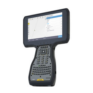
Trimble

... expand the capabilities of GE Vernova’s APM software. The ANYbotics ANYmal robot uses an open architecture software that encompasses the entire robotic stack, from motion control and localization and mapping ...
General Electric

... favourite Apps. Software development kit for seamless GNSS integration The Leica Zeno Connect Software Development Kit (SDK) is designed to integrate Leica Zeno GIS series handhelds and Leica Zeno GIS sensors with ...
Leica Geosystems
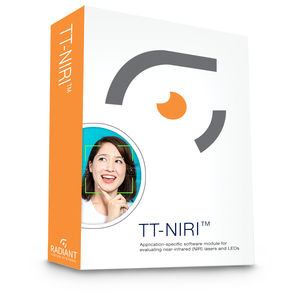
... distribution of NIR light for object detection. Part of the Radiant Vision Systems TrueTest™ Software family, the TT-NIRI module provides the benefits of TrueTest Software to efficiently perform image-based measurements, ...
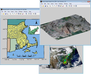
Mapping Toolbox™ provides algorithms and functions for transforming geographic data and creating map displays. You can visualize your data in a geographic context, build map displays from more than 60 map projections, and transform data ...
... even when lower grade inertial sensors are used. IE can produce results suitable for demanding applications such as mobile mapping, aerial and hydrographic surveying. IMU data from high end Fibre Optic Gyro (FOG) or Ring Laser Gyro (RLG) ...
... Secure & flexible inclusion of aggregated product & machine data in a wide variety of IT applications Secure Integration Server (SIS) provides a powerful OPC UA data integration layer. Based on the OPC UA aggregation server users implement flexible ...
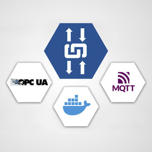
... Container-based flexible IT/OT integration solution built on OPC UA with MQTT connectivity to IoT solutions edgeAggregator provides a powerful OPC UA data integration layer combined with a modern Docker based IoT edge solution. Users implement flexible ...
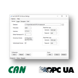
... OPC UA Server for mapping CAN frames like objects • Scalable, powerful and resource-saving OPC UA server • Platform-independent and secure data exchange for CAN fieldbus devices • Executable without active user due to implementation ...
... /strong>. Automatic generation of reports tailored to the requirements of clients and public authorities.
... Professional, efficient, and accessible mapping. Autel Mapper is a 2D and 3D reconstruction software with cloud or local processing, utilizing deep learning for highly accurate results. Swift and Accurate Autel's AI ...

... X-PAD Ultimate GO is the solution for those who need a simple and flexible field software to be used in all surveying and tracking applications with GNSS receiver and total station. Combined with our manual total station, the Zoom10(*), ...
... technologies (i.e. cable locators) and highly enhances data visualisation to take utility detection and mapping to the next level. The uViewer software is designed to operate on site with any GNSS positioning systems ...
IDS GeoRadar
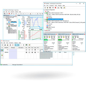
... The canAnalyser is a versatile tool for the development, testing and servicing of CAN, CAN FD and LIN based systems. The software package is based on a modular concept and available in three versions (mini, lite and standard) with a different ...
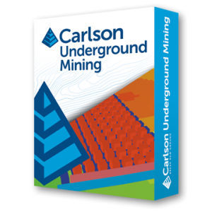
... produce accurate, customized reports with Carlson Software’s renowned ease of use. Mine plans can be quickly modified to compare alternatives, thereby ensuring the most efficient design. UNDERGROUND MINE MAPPING • ...
the best suppliers