
{{product.productLabel}} {{product.model}}
{{#if product.featureValues}}{{product.productPrice.formattedPrice}} {{#if product.productPrice.priceType === "PRICE_RANGE" }} - {{product.productPrice.formattedPriceMax}} {{/if}}
{{#each product.specData:i}}
{{name}}: {{value}}
{{#i!=(product.specData.length-1)}}
{{/end}}
{{/each}}
{{{product.idpText}}}
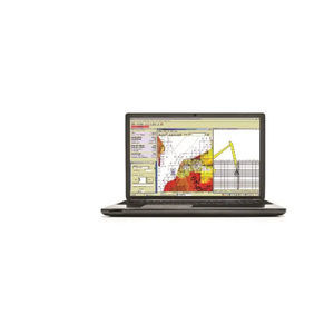
... Software for Dredging Control on Cutter Suction, Hopper, Excavators and Bucket Dredges. Designed to assist your company in monitoring its digging operations. Area maps, nautical charts and DXF files can be downloaded for geographical ...
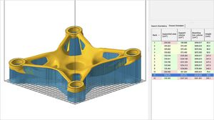
... lightweighting Why use Autodesk Fusion with Netfabb? Bring products to market faster Simplify print preparation steps like positioning, support generation, and slicing. Reduce build failures Predict and compensate for potential ...

... support software for Motion system from system designing, programming, servo adjustment, and to maintenance. System Settings With the highly graphical nature of the system settings screen, setting up servo amplifiers is easy. The ...
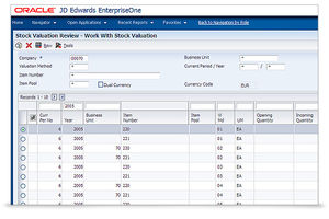
... Oracle’s JD Edwards software meets the demands for a modern and simplified user experience. Our purpose-built applications are aligned to how your users work. Integrated with digital technologies, our innovative approach increases productivity ...
...
Key features / Capabilities
- Hardware item monitoring and telemetry collection
- Software and firmware Over-The-Air (OTA) updates
- Remote app installation and remote configuration
- Device
GETAC
... known and used formats (e.g. IGES, STEP, SAT, STL etc.) or a dxf with possibility to correct possible problems in advance. Software features Simplified programming through pre-set bending cycles Possibility to introduce very ...
PRIMA POWER
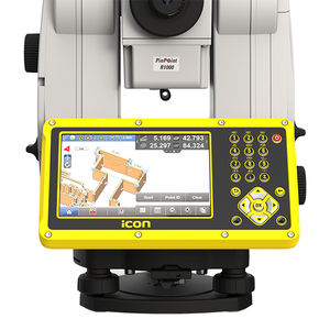
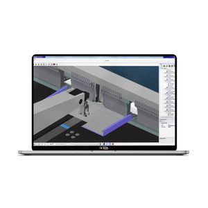
... build construction software provides versatility and flexibility for field crews to conduct layout, as-built and verification tasks on projects. Improve speed, performance and accuracy with just one custom built construction software. Leica ...
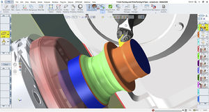
... surface finish, and increased cutting speeds. Furthermore, the inclusion of a third axis for tool rotation allows for optimal positioning of the tool, enabling the cutting of intricate shapes with a single tool. This also enables a seamless ...
GibbsCAM

... real-time data visualization, precise control, and full traceability, it enhances operational efficiency and product quality, positioning you at the forefront of intelligent manufacturing. Seamlessly integrating production, data, and ...
Hollysys
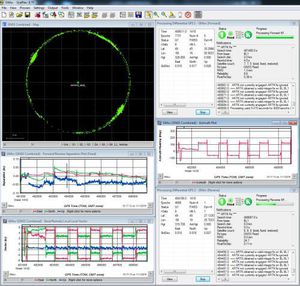
... GrafNav GNSS Post-Processing Software GrafNav post-processing software is a powerful, highly configurable processing engine that allows for the best possible static or kinematic GNSS accuracy using all available GNSS ...
NovAtel

... Professional functions for editing figures and texts Shading, user-definable shading patterns Automatic functions for positioning and alignment Contour sketching and interactive changing Numeric input methods for ...
With Suvery Master you can survey through Topo survey/Auto survey, Static and PPK modes; edit and stake points/lines. Also this App provides a convenient way to import/export surveying data files, supporting data formats: TXT, CSV, SHP and AutoCAD DXF. ...
... ComNav Cloud Based CORS Service consists of CDC.NET (main CORS stream processing engine), CDC+ (Ntrip caster software), VRS service and Base management. The service provides multi-brand reference station access, flexible and diverse data ...
... Product overview
Atom Millnet is a packaging
software that allows businesses of all sizes to collaborate, review, and approve packaging artwork online. Highly configurable, Atom Millnet is designed for brands, retailers ...
... immediately predictable. Secondary Development : It provides an interface and sample code for secondary development of the software so that users can add their own hardware or their own algorithms. AVB also provides an API for users ...

... information fully automatically. 4 - DTG Printing Automatically loading print print files of orders, controlling positioning via EPS and saving machine profiles per item and per colour is possible with Smake. Maximum error reduction ...
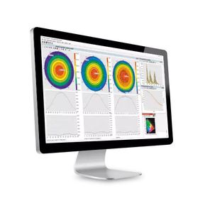
... DMS software – Automated system control and comprehensive data analysis A DMS all-in-one solution comprising of positioning system, accessories, control and analysis tools allows for complete and fully automated characterization ...

... Series or MS-ZH Series with video camera, combined with our software, personal computer and any required accessories, such as a motorized X-Y-Z axis positioning table. The C.A.M.S. software complements ...

... The GPS Waypoint Navigation Package is a hardware and software kit that allows users to select a GPS waypoint or series of waypoints from a workstation, and direct a robot to autonomously travel between the points, with support for obstacle ...

... Bevel cutting With Libellula.CUT you can program all the cutting machines: laser, plasma, oxycutting, water jet. The software is designed to allow you to achieve the best cutting results, saving material, reducing time and making ...
Libellula S.r.l

... enhances data visualisation to take utility detection and mapping to the next level. The uViewer software is designed to operate on site with any GNSS positioning systems as well as maximise user experience and intuitiveness ...
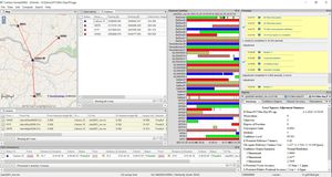
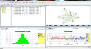
... office software • Do quality control of GNSS data before export to Survey or GIS software CARLSON SURVEYGNSS AT A GLANCE • Supports differential post-processing of RINEX GNSS observations in static, ‘stop and go’ ...
... optimal part and assembly design. Applications can leverage CDS for regenerating features by re-calculating the sketches and positioning components of an assembly. Comprehensive Functionality Constraint Design Solver (CDS) allows ...
... the Product Overview. Software: Please access our Distributor's Corner to download the instruction documents. Field data collection software compatibility FieldGenius from MicroSurvey SurvCE from Carlson ...
... Control software for frame-oriented X-ray systems: XoroYa and pYcaXo. With a very simple interface, this software allows to obtain the different digital X-rays of a large frame in a fast way. Main features Very ...
Novadep NDT Systems
... S7 configuration using ConfigStage is child's play. This free Windows software for parameterizing the CPU and communication interfaces is intuitive to learn. The graphical assignment (mapping) of external Modbus and CAN devices in the ...
the best suppliers