
{{product.productLabel}} {{product.model}}
{{#if product.featureValues}}{{product.productPrice.formattedPrice}} {{#if product.productPrice.priceType === "PRICE_RANGE" }} - {{product.productPrice.formattedPriceMax}} {{/if}}
{{#each product.specData:i}}
{{name}}: {{value}}
{{#i!=(product.specData.length-1)}}
{{/end}}
{{/each}}
{{{product.idpText}}}
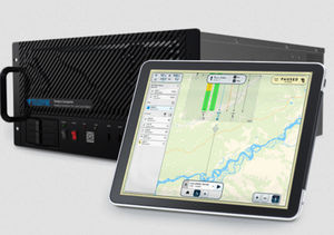
Galaxy Onboard is designed for Airborne Lidar applications that demand real-time data, and businesses who want to increase their ROI with the ability to produce and deliver projects faster. Galaxy Onboard extends the industry-leading Galaxy sensor into ...
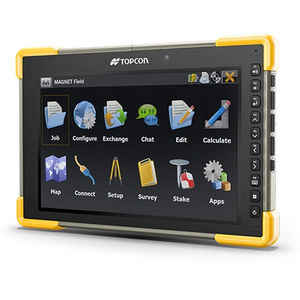
... Powerful layout, surveying, and construction workflows in the palm of your hand Easy to use and learn 3D layout Data handling Professional field-based, quality reporting Map-based workflows Hybrid GNSS and total stations control Harness ...
TOPCON
... application for surveying, drainage, subsurface utilities, and roadway design that supersedes all capabilities previously delivered through InRoads, GEOPAK, MX, and PowerCivil. You Don’t Work in a Silo and Neither Should Your Software ...
Bentley Systems Europe B.V.
... A leading field software used by professional surveyors around the world, Trimble® Access™ software delivers functionality that supports efficiency, accuracy and ease of use with simplified workflows. Benefits and ...
Trimble

... One software for all workflows From import to final drawings, X-PAD Office Fusion offers you the best tools without having to pass data from one program to another. You can load data from total stations, GPS, digital levels and laser ...
GeoMax

... Infinity is more than a user-friendly geospatial office software for measurement professionals - it’s a productivity powerhouse connecting field and office like never before. In one intuitive software, easily manage ...
Leica Geosystems

... jobsite. Powerful tools help you quickly and easily create accurate, integrated 3D constructible models for construction surveying and machine control. Note – when you click the button below to request a 30-day free trial for Trimble ...
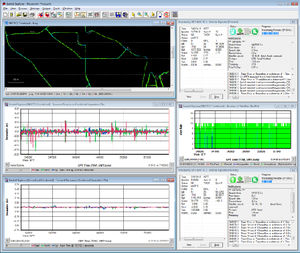
... sensors are used. IE can produce results suitable for demanding applications such as mobile mapping, aerial and hydrographic surveying. IMU data from high end Fibre Optic Gyro (FOG) or Ring Laser Gyro (RLG) IMUs, and from lower grade ...
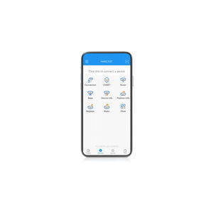
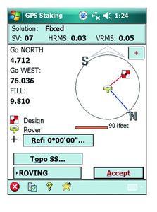
... Auto survey, Static and PPK modes; edit and stake points/lines. Also this App provides a convenient way to import/export surveying data files, supporting data formats: TXT, CSV, SHP and AutoCAD DXF. Compatible with most of Android ...
... networks Data acquisition, processing and reporting software, able to handle networkly thousands of AQMS stations and monitors in a town, city or region. The XR® environmental management software by ENVEA offer ...
... 3D reconstruction software with cloud or local processing, utilizing deep learning for highly accurate results. Swift and Accurate Autel's AI deep-learning algorithms make Autel Mapper the one of the quickest map processing software ...

... -based solution. AiMaps is a SaaS solution leveraging Artificial Intelligence for a new smart productivity in Utility surveying. AiMaps, fully integrated with the existing IDS GeoRadar IQMaps, exploits Hexagon’s HxDR platform for Reality ...
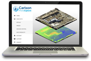
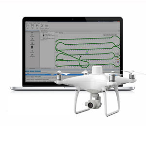
... OVERVIEW Aerial surveying and drone photogrammetry is rapidly becoming a vital part of any surveyor’s toolkit. Thousands of people use drone site flyovers every day to help boost efficiency and lower costs. With Carlson PhotoCapture ...
... orthomosaics, composite satellite imagery, and more. Inverse & Traverse Adjust designs for the field You no longer need 3rd party software to convert survey plans into real field projects. The Traverse tool allows you to create new ...
... Justin software is an indispensable tool for wide range of geodetic and surveying tasks. It combines high performance, flexibility for post-processing GNSS observations with GIS interface and features. The Justin software ...

... the workflow is fully automated. Facilitated Problem Solving Reach a fully automated workflow faster in a user-friendly software environment. Reports with Statistics & Curve Fitting Don't waste time creating reports with built-in ...
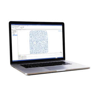
MIPAR
... option is only available in combination with the AndroTec Geo-Data Converter and allows easy Import/Export of plans to/from surveying file formats like CSV, TXT, Sokkia SDR33, Leica GSI, REB (DA30, DA45, DA4) and more. Kubatura: This ...
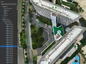
... Standalone application that allows to display, edit and analyze clouds of millions of points captured by fixed or mobile scanners, LiDAR technology or generated by photogrammetry applications. Point clouds can be imported in the most common formats on ...
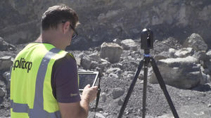
Aplitop
... Spectra Precision® Survey Pro field software provides you with a complete set of capabilities for all your survey projects. It's fast, reliable and easy to use. Transfer data from Survey Pro to your laptop or PC and manage your jobs using ...
Spectra Precision

... designed to help efficiently complete high-precision surveying and mapping projects. Landstar 8 is versatile and integrates all surveying features for different applications, including construction surveying, ...
CHC Navigation | CHCNAV
... CHC Geomatics Office Software (CGO) 2.0 is a powerful office software solution designed for engineers as an integrated platform to make a link between field and office workflow from multiple sensors and generate rich ...
CHC Navigation | CHCNAV

... opening third-party software for the positioning and orientation system (POS) computations. It enables the analysis of complex information structures with absolute precision and empowers the world of 3D data processing. CoPre software ...
CHC Navigation | CHCNAV
... file with position information or geotagged images can then be used directly in major photogrammetric mapping or 3D Survey software. Ultimate Efficiency Reduced Workload The PPK method makes it possible to perform high-precision ...
... HBC, the all-in-one post-processing desktop software, supports processing multi-sourced data from all kinds of surveying equipment, including RTK, total station, UAV, GIS, 3D laser and levels. This one-stop service simplifies ...

... Advanced AR stakeout function will help users improve the efficiency and accuracy of data staking out without focusing on the software interface in real-time. With the intelligent voice prompts, users can accurately determine the direction ...
Windows® interface for adjusting parameters, troubleshooting and recording the parameters of Curtis products with a serial connection.
the best suppliers