
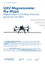
3-axis magnetometer R4-M350

Add to favorites
Compare this product
Characteristics
- Options
- 3-axis
Description
Magnetometer for DJI M350 Drone and Ground Use with uBlox
The UAV Magnetometer R4-M350 is an ultra-portable magnetometer designed for integration with drones, particularly the DJI Matrice 350 RTK (M350), or for handheld use. This system is ideal for conducting surveys over large areas, optimizing survey times compared to ground surveys thanks to the PPS function, which can be activated with the uBlox module.
Main Features of the MagDrone R4:
- Sensors: Equipped with five tri-axial Fluxgate sensors arranged horizontally and in parallel, with a spacing of 250 or 500 mm.
- Sampling Frequency: Operates at 200 Hz, effectively filtering out noise from infrastructure or drone motors.
- Internal Memory: Comes with 8 GB of internal memory for data recording during survey operations.
- User Interface: The system is controlled via a single button and an integrated Wi-Fi server, accessible from any Wi-Fi-enabled device (smartphone, tablet, or laptop), facilitating configuration and monitoring.
- Weight: Approximately 1,400 g, compatible with drones capable of carrying a payload of at least 1.5 kg.
- uBlox GPS Module: Thanks to the integrated uBlox GPS module, the UAV Magnetometer R4-M350 can acquire data at high speeds (up to 5 m/s) and be used in handheld ground mode. The operator can detach the magnetometer from the drone and use it on the ground, enabling georeferenced surveys in environments where flying is not possible.
- Data Processing Software: Compatible with geophysical analysis software for generating detailed magnetic maps (Oasis or Surfer).
Catalogs
Other Novatest products
Drones


*Prices are pre-tax. They exclude delivery charges and customs duties and do not include additional charges for installation or activation options. Prices are indicative only and may vary by country, with changes to the cost of raw materials and exchange rates.