
Data analysis software GEOLITIXoffice3Dcloud

Add to favorites
Compare this product
Characteristics
- Function
- data analysis
- Applications
- office
- Type
- 3D
- Deployment mode
- cloud
Description
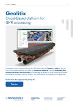
Developed to be a complete solution for GPR data analysis, Geolitix is easy to use yet has all the complex features you need for advanced projects.
Geolitix improves your survey efficiency and accuracy by harnessing the power of cloud computing to enable the seamless importing, editing, analysis, and interpretation of underground imaging data.
Project Collaboration and Sharing
Geolitix allows you to seamlessly collaborate with colleagues with just a click. You can upload data from the field, immediately interpret it in the office and share project elements live with stakeholders. Geolitix offers licencing structures for all users, from students to large enterprises with multiple sharable licences.
Working with GPR
You can import data from any single or multichannel GPR system into Geolitix by simply dragging and dropping. Any survey geometry can be used, from simple grids to complex GNSS or total-station tracked surveys. The platform incorporates all processing and interpretation functions in a user-friendly interface. GPR data can be automatically processed using Geolitix’s unique algorithms.
REGISTER NOW: https://app.geolitix.com/signup?rid=novatest
Catalogs
Other Novatest products
Software


*Prices are pre-tax. They exclude delivery charges and customs duties and do not include additional charges for installation or activation options. Prices are indicative only and may vary by country, with changes to the cost of raw materials and exchange rates.