



- Company
- Products
- Catalogs
- News & Trends
- Exhibitions
3D scanner MetaCam Air2measurementLIDARfor surveying


Add to favorites
Compare this product
Characteristics
- Number of axes
- 3D
- Applications
- measurement
- Technology
- LIDAR
- Application domain
- for surveying
- Configuration
- compact, portable, hand-held, mobile
- Other characteristics
- high-precision, color, with integrated electronics, simultaneous localization and mapping (SLAM)
Description
Overview
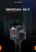
The MetaCam Air 2 integrates a tightly coupled multi-sensor unit and AI-driven SOTA-SLAM to produce high-accuracy point clouds in multiple formats. Its compact, handheld form factor enables rapid deployment and scanning on the move while providing real-time visual feedback for on-site quality control.
Key highlights
SOTA-SLAM and Accuracy
The SLAM system is trained on extensive real-world data to deliver engineering-grade results. Users obtain clean, reliable point clouds with centimeter-level relative accuracy and minimal point cloud thickness directly from the field.
Modes, Outputs and Reconstruction
Smart Scan Resumption (large-scale projects)
Software ecosystem
Feature demonstrations & visualization
The product page shows intensity vs. colorized modes, TimeSync and multi-source fusion, extended operation demos, automatic merging workflow, and 3DGS reconstruction examples illustrating real scan results and deliverables.
Industry applications
Technical specifications
The MetaCam Air 2 integrates a tightly coupled multi-sensor unit and AI-driven SOTA-SLAM to produce high-accuracy point clouds in multiple formats. Its compact, handheld form factor enables rapid deployment and scanning on the move while providing real-time visual feedback for on-site quality control.
Key highlights
- Ultralight handheld: 619 g
- Compact body for instant deployment and mobile scanning
- AI-driven SOTA-SLAM for stable mapping in feature-sparse and complex environments
- < 1 cm relative accuracy and < 1 cm point cloud thickness
- Real-time color preview with full coverage for on-site QA
- Intensity Mode and Colorized Mode (dual visualizations)
- Improved field productivity — up to 5× efficiency gains
- TimeSync 3.0: microsecond-level hardware synchronization across sensors
- Tightly coupled advanced multi-source fusion with strong self-correction
SOTA-SLAM and Accuracy
The SLAM system is trained on extensive real-world data to deliver engineering-grade results. Users obtain clean, reliable point clouds with centimeter-level relative accuracy and minimal point cloud thickness directly from the field.
Modes, Outputs and Reconstruction
- Real-time point cloud preview on device
- Exports high-accuracy point clouds in multiple formats for downstream processing
- 3D Gaussian Splatting (3DGS) for immersive photorealistic reconstruction with measurable spatial detail
Smart Scan Resumption (large-scale projects)
- Extended operation: resume exactly where a session stopped to avoid battery/session limits
- Flexible workflows: plan large scans across multiple sessions and segments
- Automatic merging: one-step merge and automatic alignment in MetaCam Studio (no manual registration)
Software ecosystem
- MetaCam Go (APP): real-time preview, on-site quality checks, device status monitoring
- MetaCam Studio (PC): one-click point cloud processing with optimization, editing, and multi-format export
- MetaCam Cloud: cloud-based point cloud processing and 3DGS rendering with online preview for collaboration
Feature demonstrations & visualization
The product page shows intensity vs. colorized modes, TimeSync and multi-source fusion, extended operation demos, automatic merging workflow, and 3DGS reconstruction examples illustrating real scan results and deliverables.
Industry applications
- Digital Factory — digital twins for production optimization
- Geospatial — 3D reality modeling and geospatial databases
- Robotics — real-to-sim for embodied intelligence and perception
- AEC — progress monitoring, BIM verification, as-built digitization
- Interior Renovation — complete room capture for design and planning
- Media & Entertainment — high-fidelity 3D asset capture for virtual production and games
- Cultural Heritage — non-invasive digital preservation for restoration and exhibition
- Forestry — sub-canopy terrain capture for inventory and management
Technical specifications
- Model name: MetaCam Air 2
- Weight: 619 g (handheld)
- Relative accuracy: < 1 cm
- Point cloud thickness: < 1 cm
- Sensor system: tightly integrated multi-sensor unit (multi-source fusion)
- Synchronization: TimeSync 3.0 — microsecond-level hardware synchronization across sensors
- SLAM: AI-driven SOTA-SLAM trained on extensive real-world data
- Visualization modes: Intensity Mode and Colorized Mode
- On-site QA: real-time color preview for immediate quality checks
- Workflow: Smart Scan Resumption and automatic merging in MetaCam Studio
- Software: MetaCam Go (app), MetaCam Studio (PC), MetaCam Cloud (cloud processing & 3DGS)
- Outputs: high-accuracy point clouds and 3D Gaussian Splatting (3DGS) reconstructions
VIDEO
Catalogs
Other SkylandX products
HANDHELD LiDAR SCANNERS


Related Searches
- 3D scanning system
- Measurement scanning system
- Inspection scanning system
- High-precision scanning system
- Compact scanning system
- High-speed scanning system
- Portable scanning system
- Color scanner
- LIDAR scanning system
- Non-contact scanner
- Mobile scanning system
- Hand-held scanner
- Production line scanner
- Measuring scanning system
- Mapping scanning system
- Scanner with integrated electronics
- Surveying scanner
- High-rate scanner
*Prices are pre-tax. They exclude delivery charges and customs duties and do not include additional charges for installation or activation options. Prices are indicative only and may vary by country, with changes to the cost of raw materials and exchange rates.
About DirectIndustry
DirectIndustry is a marketplace that offers B2B players a complete experience, from product sourcing to purchase. DirectIndustry is an entity of VirtualExpo Group.
Are you a buyer?
Are you a supplier?