

{{product.productLabel}} {{product.model}}
{{#if product.featureValues}}{{product.productPrice.formattedPrice}} {{#if product.productPrice.priceType === "PRICE_RANGE" }} - {{product.productPrice.formattedPriceMax}} {{/if}}
{{#each product.specData:i}}
{{name}}: {{value}}
{{#i!=(product.specData.length-1)}}
{{/end}}
{{/each}}
{{{product.idpText}}}

... ATLASCAN Max Scan where you want | Inspection in your hands From Hexagon’s first-ever range of handheld 3D scanners, the ATLASCAN Max allows you to easily scan whatever you want, wherever you want – just use your hands. Multi-mode ...

... The HiScan-C is a fully integrated mobile mapping system with Hi-Target advanced 3D laser and geo-referenced digital imagery which proofed to be a perfect solution when a massive amount of asset data needs to be collected in a short time. ...
... Mobile Mapping Versatile 3D mapping laser technology is adaptable to any environment in all industries, and is especially well suited to complex and enclosed spaces. Rapid Scanning Within minutes you can collect ...
Measuring distance: 0.3 m - 365 m
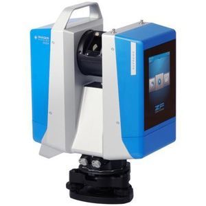
... is a 3D laser scanner for demanding surveying projects. It provides flexibility, stability and precision for close-range and mid-range measurements with a measurement range from 0.3 m up to 365 m. The device can be used as a static scanner ...
Zoller + Fröhlich

Measuring distance: 0.3 m - 150 m
... Overview
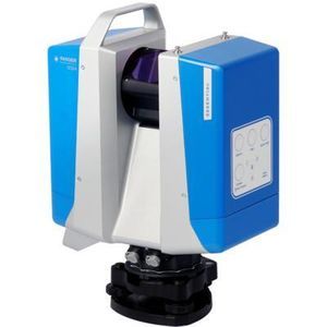
The Z+F IMAGER® 5024 Advanced is a 3D laser
scanner designed for fast, efficient surveying tasks. It combines flexibility, stability and consistent data quality for close-range and mid-range operations up to 150 m.
Data ...
Zoller + Fröhlich
Measuring distance: 0.3 m - 80 m
... Overview
The Z+F IMAGER® 5024 Essential is a 3D laser
scanner engineered for efficient surveying work at close to mid ranges. It supports static scanning up to 80 m and provides flexible operation via on-device control and a ...
Zoller + Fröhlich

Measuring distance: 0 m - 120 m
... The LS300 Laser Scanner uses SLAM technology (simultaneous localization and mapping), which is real-time positioning and mapping technology. It does not rely on GNSS positioning, and performs self positioning ...

... Family of handheld 3D Laser Scanners with accuracies up to 0,01 mm capable of acquiring point clouds very quickly. The scanner works with multiple laser blades or on a single blade. Ideal for measuring open surfaces and ...
... Status information display and system parametrization via user interface Main Applications - Coastline and Shallow Water Mapping - River and Water Reservoir Surveying - Monitoring Tasks in Hydro Engineering and Harbor Management - Hydro ...
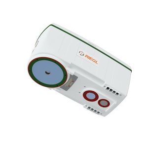
RIEGL LMS

Length: 382 mm
Width: 228 mm
Measuring distance: 0.5 m - 50 m
The Q1 Laser RADAR is a 3D optical metrology tool for precise measurement. It is designed for simplicity and cost-efficiency. With 128 parallel channels, it offers high accuracy and fast, non-contact data collection. It suits various industrial and field ...
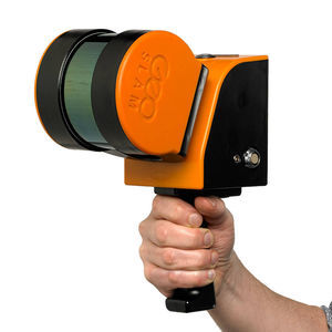
... provides texture information, while a visual camera guarantees stronger real time preview with GOapp. Mapping results are generated immediately inside the scanner, right after scanning: choose if you want to color them ...
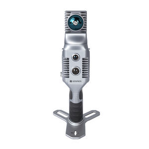
Stonex

Length: 905, 1,550 mm
Measuring distance: 0 m - 2,000 m
... MS series 3D Mapping LiDAR scanners are TOF LiDARs that designed for achieving 3D detection and imaging, accurately obtaining the surrounding environment information. With various maximum detection distances from 150m ...

The RS10 brings a new approach to geospatial surveying by integrating GNSS RTK, laser scanning, and visual SLAM technologies into a single platform designed to improve the efficiency and accuracy of indoor and outdoor 3D scanning and surveying tasks. ...

Length: 262 mm
Width: 142 mm
... The AlphaUni 20 (or AU20) is a cost-effective, multi-platform mobile mapping system of premium class. As a result of six years of innovation and product development, it harnesses the power of CHCNAV's state-of-the-art LiDAR technology. ...
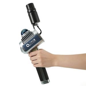
... specifications
- Product title: Portable 3D LIDAR Scanner - Qianxun SI
- Brand: Qianxun SI
- Commercial name: H7
- Page slug: scanner-H7
Applications
Suitable ...

... The lightweight Cygnus Lite handheld LiDAR scanner redefines data collection with its 20° tilt mechanism, dual wide-angle cameras, and an integrated RTK module. It captures unprecedented detail and vibrant color in every scan, ensuring ...
the best suppliers