

{{product.productLabel}} {{product.model}}
{{#if product.featureValues}}{{product.productPrice.formattedPrice}} {{#if product.productPrice.priceType === "PRICE_RANGE" }} - {{product.productPrice.formattedPriceMax}} {{/if}}
{{#each product.specData:i}}
{{name}}: {{value}}
{{#i!=(product.specData.length-1)}}
{{/end}}
{{/each}}
{{{product.idpText}}}

The HiScan-C is a fully integrated mobile mapping system with Hi-Target advanced 3D laser and geo-referenced digital imagery which proofed to be a perfect solution when a massive amount of asset data needs to be collected in a short time. By combining ...

Measuring distance: 0 m - 130 m
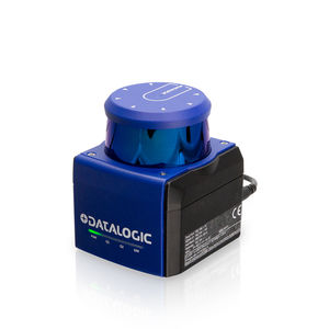
... tool Self-check function for increasing system availability Reliable and precise, even over long distances The LMS5xx 2D LiDAR sensor is the successor of the successful LMS2xx family. With numerous innovative functions, the LMS5xx ...

... Can repeat scan missions autonomously for up-to-date project progress and site changes Uses GrandSLAM technology: LiDAR SLAM, Visual SLAM, and an IMU for reality capture and autonomous navigation through complex environments With ...
Leica Geosystems
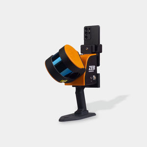
... A versatile tool to capture, process and understand the world around you – with real-time feedback. A mobile LiDAR scanner with high versatility, ZEB Horizon RT is the ideal solution for a variety of workflows including ...
FARO
Measuring distance: 0.3 m - 365 m
... is a 3D laser scanner for demanding surveying projects. It provides flexibility, stability and precision for close-range and mid-range measurements with a measurement range from 0.3 m up to 365 m. The device can be used as a static scanner ...
Measuring distance: 1 m - 300 m
... Powered by industry-leading SLAM algorithms, the LS1 combines LiDAR, vision sensors, and integrated RTK capabilities to achieve real-time centimeter-level precision. It features full-scale, real-time color point cloud output and an instant ...
Length: 323 mm
Width: 217 mm
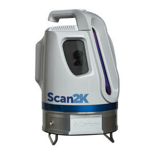
Measuring distance: 750 m - 1,000 m
... mount • Configurable for tripod or mobile deployment ONE SCANNER TO RULE THEM ALL Beyond the impressive 2,000 meter range of the Scan2K and 750 meter range of the Scan750, these scanners also have short- and medium-range ...

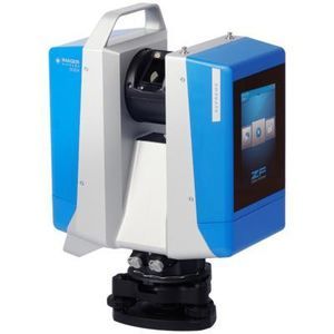
... RIEGL‘s latest generation of professional Terrestrial Laser Scanners stands out with extreme versatility, high productivity, ultimate performance and additional mobility – providing an excellent return on investment! The RIEGL VZ-600i ...
RIEGL LMS

Length: 382 mm
Width: 228 mm
Measuring distance: 0.5 m - 50 m
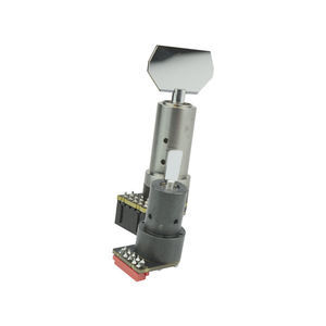
The Q1 Laser RADAR is a 3D optical metrology tool for precise measurement. It is designed for simplicity and cost-efficiency. With 128 parallel channels, it offers high accuracy and fast, non-contact data collection. It suits various industrial and field ...
Ommatidia
Measuring distance: 1 mm - 50 mm
... The ScannerMAX ARC-Series represents an entirely new way of constructing an optical scanner, designed specifically for high-volume manufacturing. A small number of precision parts are assembled together along with a highly optimized rectangular ...
... the photoelectric sensor inside the 2D LiDAR. By measuring the flight time of each laser beam from emission to reception, the distance between each detection point of the material surface contour line and the 2D LiDAR ...
RETTAR

Length: 120 mm - 650 mm
Width: 80 mm - 120 mm
Measuring distance: 100 mm - 2,000 mm
... augmented reality. In industrial settings, our scanner can be used for inspection of complex parts and surfaces, ensuring they meet strict quality standards. In product design and prototyping, our scanner can capture ...
... There are many technical routes for Automotive lidar in terms of ranging principle, laser emission, laser reception, beam manipulation and information processing. Compared with other routes, Leishen Intelligence finally chose the rotating ...
Shenzhen Leishen Intelligent system Co., LTD

Measuring distance: 6, 8 m
... The R2100 multi-beam LED scanner overcomes the barrier of what is possible by combining Pulse Range Technology with Ultra-IR LED LEDs and multi-beam reading. Several LED elements transmitters located next to each other offer a two-dimensional ...

The RS10 brings a new approach to geospatial surveying by integrating GNSS RTK, laser scanning, and visual SLAM technologies into a single platform designed to improve the efficiency and accuracy of indoor and outdoor 3D scanning and surveying tasks. ...

Length: 262 mm
Width: 142 mm
... class. As a result of six years of innovation and product development, it harnesses the power of CHCNAV's state-of-the-art LiDAR technology. The AU20 excels in airborne scenarios, delivering superior data and increasing survey efficiency ...
Measuring distance: 0 m - 50 m
... ToF technology on infrared laser 360° measurement for all-round scanning Differentiation between natural objects and reflectors Compact design for easy mechanical integration Simple and quick configuration and monitoring High ...
... specifications
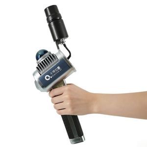
- Product title: Portable 3D LIDAR Scanner - Qianxun SI
- Brand: Qianxun SI
- Commercial name: H7
- Page slug: scanner-H7
Applications
Suitable ...

... The lightweight Cygnus Lite handheld LiDAR scanner redefines data collection with its 20° tilt mechanism, dual wide-angle cameras, and an integrated RTK module. It captures unprecedented detail and vibrant color in every ...

Length: 97 mm
Width: 95 mm
Measuring distance: 50 m
... Lidar Guidance Scanner is a compact, rugged navigation Lidar based on time-of-flight (TOF) infrared laser technology for the market of Automated and Laser Guided Vehicles or Forklifts, used for intralogistics ...
DATASENSING
the best suppliers