
{{product.productLabel}} {{product.model}}
{{#if product.featureValues}}{{product.productPrice.formattedPrice}} {{#if product.productPrice.priceType === "PRICE_RANGE" }} - {{product.productPrice.formattedPriceMax}} {{/if}}
{{#each product.specData:i}}
{{name}}: {{value}}
{{#i!=(product.specData.length-1)}}
{{/end}}
{{/each}}
{{{product.idpText}}}

... third-party software Intuitive and flexible point cloud processing Process, combine and analyze multi-source point cloud data from traditional survey instruments as well as reality-capture laser scanners, mobile mapping systems and ...
... core processing and utilities as Inertial Explorer along with simplified functions and workflows that have been tailored for UAV markets and small project areas. Data can be post-processed efficiently without compromising position, velocity ...
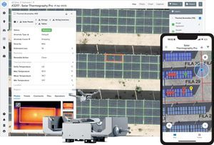
... Automated Inspections with Drones & Robotics - Leverage drones and robotics to collect high-resolution visual and thermal data, reducing inspection time from days to hours. - Conduct IEC thermographic inspections with ...
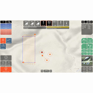
... planning software provides superior situational awareness and safety of UAS operations through a user-friendly GUI and intuitive control. With the C-ASTRAL C³P (Command, Communications, Control and Planning) software ...
... Standalone application that allows to display, edit and analyze clouds of millions of points captured by fixed or mobile scanners, LiDAR technology or generated by photogrammetry applications. Point clouds can be imported in the most common formats on ...

... comprehensive industry-standard data import and export formats allow LandStar 8 to be seamlessly integrated into existing software environments and ensure instant productivity. ...
... CHC Geomatics Office Software (CGO) 2.0 is a powerful office software solution designed for engineers as an integrated platform to make a link between field and office workflow from multiple sensors and generate rich ...
... supported data formats, mathematical functions and visualisations • Optimized for generic research jBEAM Lab data analysis software comes in three different versions: • Starter for entry level usage • Professional for experienced ...
the best suppliers