

{{product.productLabel}} {{product.model}}
{{#if product.featureValues}}{{product.productPrice.formattedPrice}} {{#if product.productPrice.priceType === "PRICE_RANGE" }} - {{product.productPrice.formattedPriceMax}} {{/if}}
{{#each product.specData:i}}
{{name}}: {{value}}
{{#i!=(product.specData.length-1)}}
{{/end}}
{{/each}}
{{{product.idpText}}}

... ATLASCAN Max Scan where you want | Inspection in your hands From Hexagon’s first-ever range of handheld 3D scanners, the ATLASCAN Max allows you to easily scan whatever you want, wherever you want – just use your hands. Multi-mode ...

... MARVELSCAN Scan where you want | Inspection in your hands From Hexagon’s first-ever range of handheld 3D scanners, the MARVELSCAN allows you to easily scan whatever you want, wherever you want – just use your hands. Multi-mode and ...
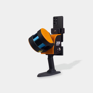
... the ZEB Horizon RT provides opportunities to lower a scanner into vent shafts or elevate it into ceiling voids, increasing user safety Capture Data Faster The lightweight nature of the scanner unlocks the potential ...
FARO

Measuring distance: 0 m - 120 m
...
The LS300 Laser Scanner uses SLAM technology (simultaneous localization and mapping), which is real-time positioning and mapping technology. It does not rely on GNSS positioning, and performs self positioning and incremental 3D mapping
...
Measuring distance: 120 m
... versatile system finds extensive applications across diverse fields including stockpile measurement, urban development, underground infrastructure digitization, agricultural and forestry analysis, as well as surveying and mapping. ...
... changing environments
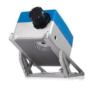
Technical specifications
- Model: Z+F PROFILER® 9025C
- Scanner type: Mobile 2D laser scanner with integrated camera system
- Profiles per second: up to 267
Measuring distance: 10 mm - 1,010 mm
... carried out directly inside scanner according to the algorithm created by the user. Measurement results can be transmitted via various protocols (Ethernet/IP, Modbus TCP, UDP), as well as to the logic outputs of the scanner ...
... Map inaccessible underground areas to ensure operations keep employees safe. C-ALS SUPPORTS SUCCESSFUL PROJECTS C-ALS gives you new underground mapping capabilities. You can safely, quickly and reliably scan inaccessible ...
Carlson Software

Length: 382 mm
Width: 228 mm
Measuring distance: 0.5 m - 50 m
The Q1 Laser RADAR is a 3D optical metrology tool for precise measurement. It is designed for simplicity and cost-efficiency. With 128 parallel channels, it offers high accuracy and fast, non-contact data collection. It suits various industrial and field ...

... hands-free operation under unpredictable environments in underground mines. This specially engineered system is a perfect multi-use tool for your advanced 3D laser data capture and mobility needs in underground mines ...

... as agricultural and forestry surveying, power line inspection, material pile volume calculation, and data collection in underground spaces. With the RS10, surveyors are able to overcome the challenges of surveying in areas with poor ...

Length: 262 mm
Width: 142 mm
The AlphaUni 20 (or AU20) is a cost-effective, multi-platform mobile mapping system of premium class. As a result of six years of innovation and product development, it harnesses the power of CHCNAV's state-of-the-art LiDAR technology. The AU20 excels ...

Measuring distance: 200, 500 mm
... easily with a single operator Measures non-cooperative targets to deliver usable data even in harsh, wet, and dusty underground conditions Fast data acquisition time lets you get in, survey, and then get out quickly, reducing ...
the best suppliers