
{{product.productLabel}} {{product.model}}
{{#if product.featureValues}}{{product.productPrice.formattedPrice}} {{#if product.productPrice.priceType === "PRICE_RANGE" }} - {{product.productPrice.formattedPriceMax}} {{/if}}
{{#each product.specData:i}}
{{name}}: {{value}}
{{#i!=(product.specData.length-1)}}
{{/end}}
{{/each}}
{{{product.idpText}}}
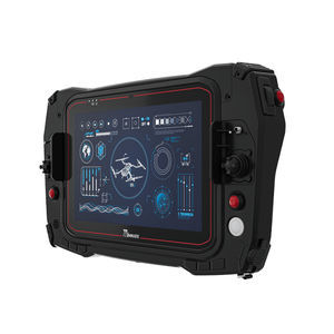
... G101G7 10.1” ARM A78 + A55 Rugged Robotic Control Station KEY FEATURES 10.1” 1920x1200 LED Panel with PCAP Touch Android 13.0/Linux Ubuntu 4G RAM + 64G eMMC ARM Genio 700 2 x A78 2.2GHz + 6 x A55 2.0GHz Supports WIFI, BT and optional 4G All-weather, ...
Winmate, Inc.
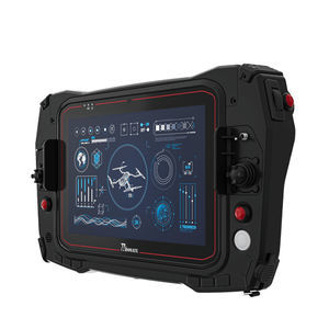
... G101TG 10.1” Intel® Tiger Lake Rugged Robotic Control Station KEY FEATURES Low Latency video SW decoder for real-time high-resolution video viewing All-weather, dust, and water-resistant design (IP65). MIL-grade drop, Shock and vibration Supports ...
Winmate, Inc.
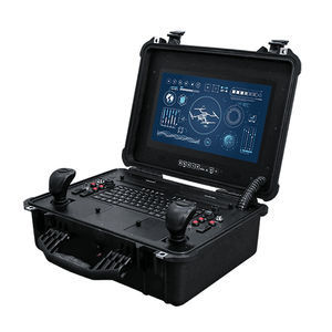
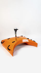
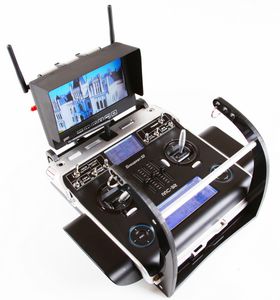
UAV ground control stationG156AD-SUIT
... 15.6-Inch Display: Features a bright and clear 15.6-inch screen, ideal for outdoor and indoor applications. Full HD Resolution: Delivers crisp and detailed visuals with 1920x1080 resolution. Rugged Design: Built to withstand harsh environments with ...
Winmate, Inc.

The APACHE 4 is an Unmanned Surface Vehicle (USV) that supports a wide variety of Acoustic Doppler Current Profiler (ADCP) systems available on the market. It offers an unmanned operation solution with a shallow draft, high navigational accuracy, and ...
CHC Navigation | CHCNAV

The APACHE 3 Pro is a compact, professional unmanned surface vehicle (USV) designed for autonomous bathymetric surveys in shallow waters. Its double-layer carbon fiber hull provides exceptional impact resistance and unsinkability. The IP67 rating guarantees ...
CHC Navigation | CHCNAV
Speed: 6 m/s
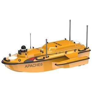
The CHCNAV APACHE 6 is an autonomous unmanned surface vehicle (USV) for high-resolution 3D bathymetric surveys, underwater object localization and offshore construction. It combines a stable triple-hull platform, adaptable dual/rotating powertrain and ...
CHC Navigation | CHCNAV

Portable and palm-sized with a built-in extension rod, DJI OM 5 is a versatile companion that unlocks the full potential of your smartphone. Enjoy flawless selfies, super-smooth video, automatic tracking, and much more. A new ShotGuides feature even provides ...
DJI-Innovations Company Limited

... Depth rated to 3000m & 6000m Modular payload ports Wide range of available sensor integrations Custom sensor integrations available Equipped with all necessary navigation sensors and support for acoustic aiding SeaRaptor offers several payload ...
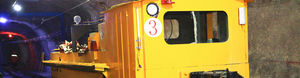
Unmanned Driving System for Underground Mine connects and controls the Signal, Integrated and Blocking system and can input production plan, locomotive operating parameters, and height of the material in winzes, etc. into central system. The system can ...
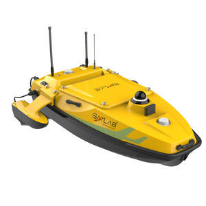
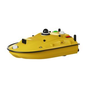
The HydroBoat 1200MB is SatLab's latest multibeam USV solution, combining proven unmanned vessel technology with the HydroBeam M2 MBES (Multibeam Echo Sounder). Compact and easy to deploy, it delivers efficient, accurate hydrographic surveys while reducing ...
SatLab Geosolutions AB
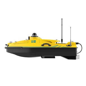
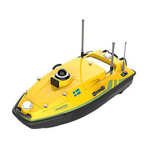
The HydroBoat 1500 is a versatile, intelligent USV that can perform underwater topographic surveys of lakes, rivers, and reservoirs by carrying the HydroBeam M4 Portable Multibeam Echo Sounder system. Equipped with a high-precision GNSS receiver and IMU ...
SatLab Geosolutions AB
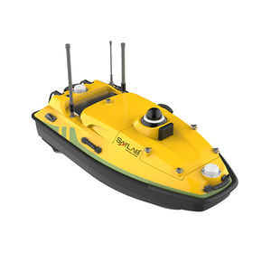
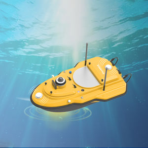
... HydroBoat 1200—an embodiment of compactness and ease, tailored for seamless operation across a spectrum of equipment. Enhanced by professional CFD technology, its stability finds new heights. Melded with high-precision single-beam echo sounder, GNSS ...
SatLab Geosolutions AB
Speed: 0 m/s - 7 m/s
Endurance: 6 h
Weight: 24 kg
The SV600 is an advanced Unmanned Surface Vessel (USV) specifically engineered for hydrographic surveys. Offering remote control capabilities, it seamlessly integrates adaptive water flow straight-line and hovering technology for enhanced efficiency. ...
Speed: 0 m/s - 7 m/s
Endurance: 180 min - 420 min
Weight: 7 kg - 30 kg
... Overview
The SV300 Unmanned Surface Vessel is a compact, highly integrated autonomous platform for hydrographic surveying and multi-parameter water monitoring. It integrates high-precision GNSS positioning, depth sounding and vessel control ...

Speed: max 6.0 m/s
Endurance: 6 min - 1,200 min
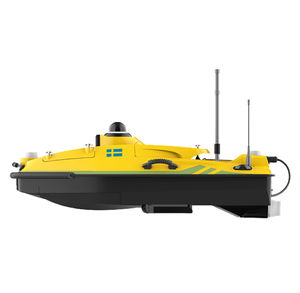
The HydroBoat 1500 is a highly versatile bathymetric survey and monitoring platform that can carry a multi-beam echo sounder. It is designed to measure underwater topography in lakes, rivers, and reservoirs. The combination of the HydroBoat1500 and the ...
Speed: 0 m/s - 6 m/s
Endurance: 300 min - 300 min
Weight: 20 kg - 20 kg
... Overview
The HydroBoat 990 is an Android-powered Unmanned Surface Vehicle (USV) designed for professional bathymetric surveys. It integrates GNSS/RTK positioning, a 200 kHz single-beam echo sounder and autonomous navigation into a compact, quickly ...
Speed: 6 m/s
Weight: 25 kg
... Overview
The HydroBoat 1200 is a multi-sensor USV platform designed for complex hydrographic surveys and environmental monitoring. Its central 240 mm moon pool accepts ADCPs, side-scan sonar, dual-frequency sounders and multi-parameter probes. ...
ELIS Tech eLagoon is a state-of-the-art aquatic drone designed to detect leaks in submerged geomembranes found in reservoirs, ponds, and industrial lagoons. Built with advanced automation and real-time GPS tracking, eLagoon ensures unmatched accuracy ...
ELIS Tech eRover is a fully autonomous land drone designed for geomembrane leak detection under soil, gravel, and other materials up to 1 meter (3.3 feet) deep. With its advanced mobility and RTK GPS tracking, eRover offers a revolutionary approach to ...
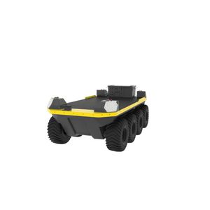
Moose UGV is our largest all-terrain unmanned ground vehicle yet. It can handle tough environments with its rugged build, low ground pressure, and 8x8 traction tires, which allow effortless mobility through soft soils, vegetation, thick muds, and steep ...
Clearpath Robotics

... Underwater ROV to remotely and safely vacuum sludge and debris accumulated on the bottom of lagoons, water drainage pipes, cooling tower basins, and underground sewage systems. - Confined spaces: can be used within confined or hazardous environments, ...
GEROTTO FEDERICO SRL
... Underwater modular vehicle platform for inspection, measurement and operation. The S-ROV is a configurable and upgradable platform for underwater inspection, measurement and operation. The ready to add technological bricks create tailored solutions ...

... water ressources management, dredging and navigation aid The environmental management, submersion and quantitative and qualitative monitoring of available water resources issues reveal the need for accurate bathymetric, hydro-sedimentary and physico-chemical ...
Robotics Industry

... The RiDrive Mobile combines in its compactness the advantages of the RiCubio® series with an efficient crawler system - for professional inspecting, especially if you cannot drive the inspection vehicle directly to the inspection area. • Compact carriage ...
Ritec Rohr-Inspektions-Technik GmbH
... The base station realizes the connecting link between the UAV and the pilot. The MikroKopter, the camera and the various functions are controlled. A simple operation is guaranteed by the preconfigured transmitters. So the MikroKopter and the transmitter ...
Mikrokopter
Speed: 1 kt - 2 kt
Endurance: 2 h - 17 h
Charging time: 3.5 h
... Surface Obstacle Avoidance coverage angle: 270° max range: 25 m / 82 ft Energy 2 batteries up to 17 h of autonomy in autonomous mode 2 to 8 h of autonomy in manual mode recharging time of 3 h 30 Removable fastening system for nets, equipments underwater ...

... The Milvus 10M is a compact, gyrostabilized turret with a 10 cm diameter, weighing approximately 650 grams. It features a Full HD day camera with 10× optical zoom and a 640×480 LWIR infrared camera with 3× optical zoom. Les caractéristiques EO: Full ...
MERIO

... Data Link for long-range telemetry for drones and UAVs with 1.5″ IPS display and encoder for Menu and data. From 313 to 950Mhz and 500mW of power with a range of 100km. It is an economical but powerful option for fully automatic flights controlled ...
Digital Micro Devices S.L

... Elastic launcher Key features: • Up to 1 kJ launch energy (16 m/s take-off velocity @8 kg MTOW - Maximum Take-Off Weight) • Man portable (16 kg weight) • Foldable construction with transport case • Catapult carriage with customizable fixed arms ...
ElevonX

... The First Smart Tethered Station for Drones Safe-T 2 is an industrial smart tethered station for UAVs, offering real-time semi-persistent observation and surveillance capabilities thanks to its patented micro-tether. Offering the widest range of compatible ...
Elistair
... Providing the reliability you need A Ground Control Station that is simple, compact, rugged and easy to carry and deploy, the G-Case contains the electronics necessary to serve as the connection point for the system. It is housed in a handy, waterproof ...
Alpha Unmanned Systems
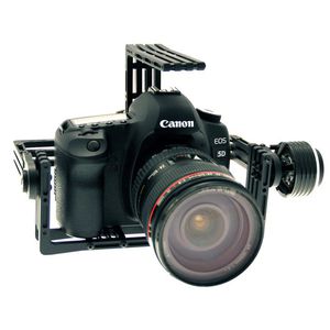
... Extremely lightweight, the OBG-1800U is a professional 2-axis gimbal made of aluminium alloy type 6061-T6 (used for aviation). As a robust camera mount, it is foreseen with sliders allowing an easy center of gravity tuning. It comes already assembled ...
Onyxstar
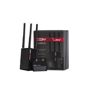
... The CONNEX Mini Video Link system supports up to 1080p60 video resolution, zero-latency performance, and has a line-of-site range of up to 1600 ft. The transmitter weighs just 2.1 ounces, making it ideal for smaller UAS, UGV, and other Industrial or ...
Teradek

... The Falcon concept is the most successful underwater electric robotic system of its class and is proven in numerous intricate and demanding missions across many commercial, security and scientific sectors. Equipped with Saab Seaeye's advanced iCON™ intelligent ...
Saab Seaeye

... BARAKUDA is a multi-purpose mule unmanned ground vehicle (UGV). ● The most powerful mule UGV of its category ● Able to carry up to 500 kg of equipment ● Designed to evacuate wounded people ● Parachutable, droppable by helicopter, and towing by vehicles ● ...
Shark Robotics (Shark Energy)