
{{product.productLabel}} {{product.model}}
{{#if product.featureValues}}{{product.productPrice.formattedPrice}} {{#if product.productPrice.priceType === "PRICE_RANGE" }} - {{product.productPrice.formattedPriceMax}} {{/if}}
{{#each product.specData:i}}
{{name}}: {{value}}
{{#i!=(product.specData.length-1)}}
{{/end}}
{{/each}}
{{{product.idpText}}}
miniature inertial navigation systemXsens MTi-7
... Global Navigation Satellite System/ inertial navigation system) with advanced sensor fusion algorithms. Self-contained Self-contained with advanced sensor fusion algorithms, ...
Xsens
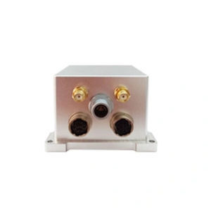
... integrated navigation system developed by Bewis for the aerial mapping, unmanned aerial vehicles, sea-based and roadbed. Built-in three-axis fiber optic gyroscope, three-axis accelerometer The BW-GI1140 is equipped ...
Wuxi Bewis Sensing Tecnology LLC
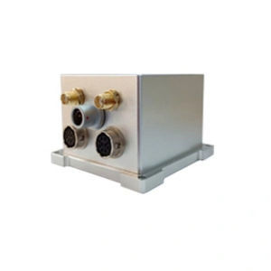
... integrated navigation system developed by Bewis for the aerial mapping, unmanned aerial vehicles, sea-based and roadbed. Built-in three-axis fiber optic gyroscope, three-axis accelerometer, The BW-GI940 is equipped ...
Wuxi Bewis Sensing Tecnology LLC
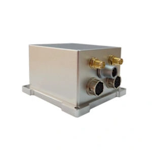
... integrated navigation system developed by Bewis for the aerial mapping, unmanned aerial vehicles, sea-based and roadbed. Built-in three-axis fiber optic gyroscope, three-axis accelerometer, The BW-GI910 is equipped ...
Wuxi Bewis Sensing Tecnology LLC
... Remote, long-endurance MEMS integrated navigation and positioning system Introduction The ER-GNSS/MINS-01 is a navigation solution that integrates satellite positioning and inertial ...
SHAANXI ERICCO INERTIAL TECH. CO., LTD
... Tactical-grade MEMS integrated navigation and positioning system Features 1.The system can provide accurate integrated navigation information, with attitude up to ...
SHAANXI ERICCO INERTIAL TECH. CO., LTD
... ER-GNSS/MINS-05 Cost-efficient GNSS aided MEMS INS Introduction ER-GNSS/MINS-05 is a Cost-efficient GNSS aided MEMS INS with a highly reliable MEMS inertial ...
SHAANXI ERICCO INERTIAL TECH. CO., LTD
... /h
/ Cost-effective, reliable, real-time position and
navigation data
/ Two survey-grade, quad-constellation GNSS receivers
/ High-quality
MEMs
inertial measurement unit gx/ix ...
... georeferencing or precision control applications. Two survey-grade, quad GNSS antennas IMU10 inertial measurement unit As a board set inertial navigation system, the ...
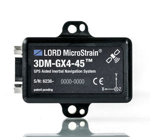
... The 3DM-GX4-45™ is a miniature, industrial-grade GPS Aided Inertial Navigation System (GPS/INS), utilizing the highest performance MEMS sensor technology. It combines ...
MicroStrain
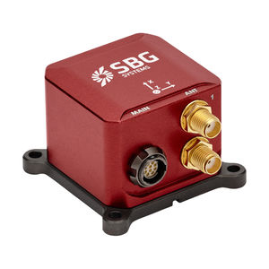
... Dual Antenna RTK INS Ellipse-D is the smallest Inertial Navigation System integrating a Dual-antenna, multi-band GNSS receiver, capable of delivering precise heading as well as centimeter ...
SBG Systems
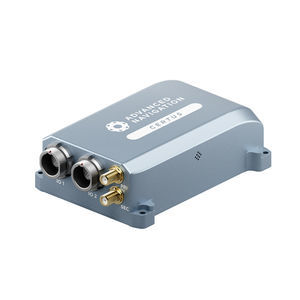
... instability prevention to ensure stable and reliable data. High-Performance MEMS Certus contains high performance MEMS sensors that are put through Advanced Navigation’s intensive 8 hour temperature ...
Advanced Navigation
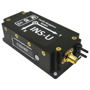
... Magnetic Compass • Small Size, light weight, low power • Affordable price The Inertial Labs GPS-Aided Inertial Navigation System (INS-U) is an IP67 rated version of ...
Inertial Labs, Inc.
the best suppliers