
Subsurface detection ground penetrating radar SUBvysorfor mapping

Add to favorites
Compare this product
Characteristics
- Application domain
- for mapping, for subsurface detection
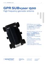
- Frequency
Min.: 70 MHz
Max.: 1,500 MHz
Description
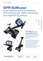
Mono-frequency and multi-frequency GPR antennas with “Telbin” technology and integrated 3D software
VGPR SUBvysor is among the most effective solutions to perform GPR surveys in a short time and at low cost thanks to the acquisition and analysis software GPR Logger and Mapper 3D.
The new GPR SUBvysor system allows the acquisition of data useful for the investigation and processing from a PC. The software also allows you to setting the data any time, keeping the original data unaltered.
GPR SUBvysorIS THE GEORADAR FOR VERY HIGH PERFORMANCE SUBSOIL INVESTIGATIONS
The wide range of antennas available (70 MHz, 125 MHz, 300 MHz, 600 MHz, 900 MHz, 1500 MHz and multi-frequency 300-700MHz) responds optimally to the different needs of the professional and to the characteristics of the terrain being inspected, even in the case of in-depth investigations or where it is required. a more accurate analysis of the subsoil and the localization of metallic and non-metallic objects of small or large dimensions.
The antennas, equipped with an integrated inclinometer, allow you to perform topographic correction of the radargram quickly and easily, with just one click. Finally, thanks to the “Telbin” signal processing technology, the signal / noise ratio is considerably increased and the data acquisition speed higher, to obtain greater resolution even in depth.
Catalogs
GPR SUBvysor - Technical Sheet
12 Pages

SUBvysor-37 GPR User Manual
29 Pages
Other Novatest products
Geophysics


Related Searches
- GNSS receiver
- Compact receiver
- Multi-channel receiver
- RTK receiver
- USB receiver
- Total station
- Surveying receiver
- Receiver with integrated antenna
- Precision level
- GPS receiver
- Reflectorless total station
- Horizontal level
- GLONASS receiver
- Ground radar
- Automated total station
- High precision receiver
- GALILEO receiver
- Total station with prism
- Optical level
- Bluetooth total station
*Prices are pre-tax. They exclude delivery charges and customs duties and do not include additional charges for installation or activation options. Prices are indicative only and may vary by country, with changes to the cost of raw materials and exchange rates.