CHCNAV mapping LIDAR sensors

1 company | 4 products
{{#pushedProductsPlacement4.length}} {{#each pushedProductsPlacement4}}
{{product.productLabel}}

{{product.productLabel}} {{product.model}}

{{#if product.featureValues}}
{{#each product.featureValues}} {{content}} {{/each}}
{{/if}}
{{#if product.productPrice }} {{#if product.productPrice.price }}

{{product.productPrice.formattedPrice}} {{#if product.productPrice.priceType === "PRICE_RANGE" }} - {{product.productPrice.formattedPriceMax}} {{/if}}
{{/if}} {{/if}}
{{#if product.activeRequestButton}}
{{/if}}
{{product.productLabel}}
{{product.model}}

{{#each product.specData:i}} {{name}}: {{value}} {{#i!=(product.specData.length-1)}}
{{/end}} {{/each}}

{{{product.idpText}}}

{{productPushLabel}}
{{#if product.newProduct}}
{{/if}} {{#if product.hasVideo}}
{{/if}} {{#each product.productTagAssociationList}}
{{/each}}
{{/each}} {{/pushedProductsPlacement4.length}}
{{#pushedProductsPlacement5.length}} {{#each pushedProductsPlacement5}}
{{product.productLabel}}

{{product.productLabel}} {{product.model}}

{{#if product.featureValues}}
{{#each product.featureValues}} {{content}} {{/each}}
{{/if}}
{{#if product.productPrice }} {{#if product.productPrice.price }}

{{product.productPrice.formattedPrice}} {{#if product.productPrice.priceType === "PRICE_RANGE" }} - {{product.productPrice.formattedPriceMax}} {{/if}}
{{/if}} {{/if}}
{{#if product.activeRequestButton}}
{{/if}}
{{product.productLabel}}
{{product.model}}

{{#each product.specData:i}} {{name}}: {{value}} {{#i!=(product.specData.length-1)}}
{{/end}} {{/each}}

{{{product.idpText}}}

{{productPushLabel}}
{{#if product.newProduct}}
{{/if}} {{#if product.hasVideo}}
{{/if}} {{#each product.productTagAssociationList}}
{{/each}}
{{/each}} {{/pushedProductsPlacement5.length}}
high-resolution LIDAR sensor
AlphaAir 6

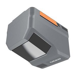
Distance range: 960 m - 2,100 m

... and mapping in mountainous or high‑relief areas.

  • Forestry and biomass assessment.
  • Road, bridge and highway corridor mapping.
  • Powerline and linear infrastructure inspection.
  • Emergency response
  • ...

    See the other products
    CHC Navigation | CHCNAV
    64-channel LIDAR sensor
    64-channel LIDAR sensor
    RS7

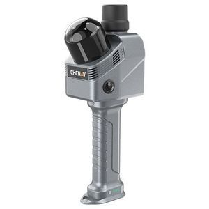
    Distance range: 0 m - 40 m

    ... is a handheld real‑time 3 D LiDAR SLAM scanner designed for interior surveying, architectural documentation and BIM-related workflows. It combines high-rate LiDAR, a high‑precision IMU and SLAM/INS fusion ...

    See the other products
    CHC Navigation | CHCNAV
    high-resolution LIDAR sensor
    high-resolution LIDAR sensor
    AlphaAir 6 Dual

    Distance range: 0 m - 2,100 m

    ... topographic surveying

  • Forestry and canopy analysis
  • Road and highway mapping
  • Power line corridor inspection
  • Emergency response and rapid mapping

  • Detailed description
    The ...

    See the other products
    CHC Navigation | CHCNAV
    high-resolution LIDAR sensor
    high-resolution LIDAR sensor
    AlphaAir 450

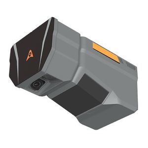
    Distance range: 450 m

    ... AlphaAir450: Airborne LiDAR system with built-in IMU, GNSS, 3 D scanner, and camera Overview: The AlphaAir 450 (AA450) is a major breakthrough in 3 D mobile mapping technology, allowing ...

    See the other products
    CHC Navigation | CHCNAV
    exhibit your products

    & reach your clients in one place, all year round

    Exhibit with us